
New developments, so new screenshots!
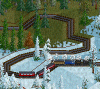
1. Trondingville, a nice coastel city, was due to it's remote location somewhat forgotten in the past which you can see here on the map.
Since it's becoming more and more attractive to tourists, the line from Brenfinburg was extended. A completely new set of High speed trains was even ordered.
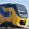
2. Here you can see the brand new station, with a HS train loading.
3. Trondingville harbour, luxurious cruise ships sail out to all destinations, and wealthier citizens sail out here for a weekend of yauchting.
Kotssmurf's screenshots
Re: Kotssmurf's screenshots
- Attachments
-
- Trondingville map.png (133.43 KiB) Viewed 1134 times
-
- Trondingville station.png (193.37 KiB) Viewed 3748 times
-
- Trondingville harbour.png (167.9 KiB) Viewed 3748 times
Re: Kotssmurf's screenshots
Continued
4. Here you can see the HS train passing a local train under way to the mountain pass.
5. Heading down again after the pass, heading for a series of bridges over a small stroke of land.
6. The complete South West corner of the map was for a long time deserted, only via the sea could you reach it. Still it was a very long, ineffecient trip.
Sanley market, which itself was remote for a long time, funded 2 lines crossing the area. In the mean time a new station was built next to the airport.
- Attachments
-
- Mountain pass 1.png
- (1.1 MiB) Downloaded 7 times
-
- Mountain pass 2.png
- (925.93 KiB) Downloaded 7 times
-
- South west.png
- (175.64 KiB) Downloaded 7 times
Re: Kotssmurf's screenshots
7. Sanley Market, the old station was upgraded to 4 platforms, and received a new building to accomodate the extra trains arriving.
In the South west corner you can see the new international station. A new goods terminal was built as wel.
8. The road to Sanley Market, where the lines to both stations split.
9. Fraston, the end point of on of the lines, where sea transport is still used to connect to the rest of the country.
In the South west corner you can see the new international station. A new goods terminal was built as wel.
8. The road to Sanley Market, where the lines to both stations split.
9. Fraston, the end point of on of the lines, where sea transport is still used to connect to the rest of the country.
- Attachments
-
- Sanley market.png
- (2.15 MiB) Downloaded 7 times
-
- Sanley market exit.png
- (2.62 MiB) Downloaded 7 times
-
- Fraston docks.png (288.8 KiB) Viewed 3744 times
Re: Kotssmurf's screenshots
10. Printing works near Slondinghead, where the passenger station can be seen as wel.
A brand new head office has been built for the administration of both the public transport in the region and the industrie. A petition has been started to demolish it immediately, since locals find it an eyesore
11. Plunfingfield, a small city next to a river, has had a major overhaul for the very old station.
12. Fonfinburg Springs station has also been adapted to actual needs, now hosting 4 platforms.
- Attachments
-
- Printing works.png
- (1.14 MiB) Downloaded 7 times
-
- Plunfinfield station.png (269.63 KiB) Viewed 3740 times
-
- Fonfinburg Springs.png (186.51 KiB) Viewed 3740 times

Re: Kotssmurf's screenshots
Really nice shots! Love your style. Hope you will show us some more
Re: Kotssmurf's screenshots
Hi all!
It's been rather long time since I've posted some screenshots so here we go.
Still playing the same game as before (for well over a year now) but the last months have seen some major changes.
In this post I will present to you two big urban areas.
1. Deburg Springs
Deburg Springs is the cultural capital of the country, and a hub for artists of all kinds. It has been one of the first cities to implement passenger rail on a large scale.
Over the years it has merged with it's two neighboring communities, Chartborough Bay and Slondinghead.
3 main railroads pass the area roughly from East to West with a focus on the main East - West connection which includes the 3 most extensively used passenger station of the entire region.
The first of these stations we can see here, namely Slondinghead Central. Situated on the West side of the city it's heavily used by laborers working in the nearby Printing works factory.
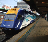
The next station in line is Deburg Springs Central, which has been shown in this thread before. It's the only station in the Urban region which is serviced by High Speed trains.
With more then 10 different lines passing through and 4 HS lines terminating it's reaching it's maximum capacity, which is why more and more lines passing the city, and not terminating in Chartborough Bay use the bypass line, but more on that later. Since there is no room for more expanding this station, the focus will shift more and more away from the East - West connection.
Also note the experimental Turbo train, the government has admitted that it was a poor decision to put an experimental train on of the most crowded lines, since it has broken down in stations multiple times causing massive delays. It will soon be used on a local line serving distant towns.
It's been rather long time since I've posted some screenshots so here we go.
Still playing the same game as before (for well over a year now) but the last months have seen some major changes.
In this post I will present to you two big urban areas.
1. Deburg Springs
- Deburg Springs Overview.PNG (14.73 KiB) Viewed 3327 times
Over the years it has merged with it's two neighboring communities, Chartborough Bay and Slondinghead.
3 main railroads pass the area roughly from East to West with a focus on the main East - West connection which includes the 3 most extensively used passenger station of the entire region.
The first of these stations we can see here, namely Slondinghead Central. Situated on the West side of the city it's heavily used by laborers working in the nearby Printing works factory.
- Slondinghead Central.PNG (258.43 KiB) Viewed 3327 times
With more then 10 different lines passing through and 4 HS lines terminating it's reaching it's maximum capacity, which is why more and more lines passing the city, and not terminating in Chartborough Bay use the bypass line, but more on that later. Since there is no room for more expanding this station, the focus will shift more and more away from the East - West connection.
- Deburg Springs Central.PNG (210.55 KiB) Viewed 3327 times
Re: Kotssmurf's screenshots
The last station on the East - West line is the terminus for Chartborough Bay; Chartborough Bay is the richest part of the city, and since the southern part is filled with canals and water, this is the only centre station of the community.
The end of many lines going West and and the incomplete Inner city loop, it's used rather heavily, but has some space to increase capacity. Once the city loop is finished the frequency of the service will be heavily increased.
The station is built at ground level, to limit noise for the wealthy community.
Chartborough bay's second and last station, Chartbourgh Bay East. This station is only halted by one out of 2 trains.
Deburg Springs West is a relatively new station. There used to be a small park at this location, but with the city centre rapidely expanding it was economically viable to construct a station here.
To compensate for the park a huge Nature reserve has been opened away from city borders for all citizens to relax and enjoy nature. The popularity of this park has been no suprise.
The end of many lines going West and and the incomplete Inner city loop, it's used rather heavily, but has some space to increase capacity. Once the city loop is finished the frequency of the service will be heavily increased.
The station is built at ground level, to limit noise for the wealthy community.
- Chartborough Bay Central.PNG (230.24 KiB) Viewed 3318 times
- Chartborough Bay East.PNG (136.16 KiB) Viewed 3318 times
To compensate for the park a huge Nature reserve has been opened away from city borders for all citizens to relax and enjoy nature. The popularity of this park has been no suprise.
- Deburg Springs West.PNG (137.8 KiB) Viewed 3318 times
Re: Kotssmurf's screenshots
Southern Chartborough Bay has turned out to be a beautifull area, which lots of water, 2 peninsulas and 2 small islands. For this reason the housing prices are incredibly high.
On the bottom of the screenshot we can see the main line going to Deburg Springs Central splitting up to service the southern Deburg Springs city line.
The two South center stations of Deburg Springs. Since the line has been constructed it has been a very welcome alternative for the mail East - West line.
The steep mountain sides have proved a very difficult and expensive soil for rail construction, and thus it's capacity is limited, too limited for the current demand.
It's crystal clear that in the future this line as well will suffer from under capacity. Multiple studies are verifying the possibility to elevate the rails and implement 3 platform stations as well as a decent station approach from both East and West. So far the only sure outcome is it will be very expensive.
Deburg Springs East, coupled with the Goods and Food terminal which is unused at the moment due to most goods coming in via boat.
The passenger station was already built for growth, with a decent 3 platform setup.
On the bottom of the screenshot we can see the main line going to Deburg Springs Central splitting up to service the southern Deburg Springs city line.
The two South center stations of Deburg Springs. Since the line has been constructed it has been a very welcome alternative for the mail East - West line.
The steep mountain sides have proved a very difficult and expensive soil for rail construction, and thus it's capacity is limited, too limited for the current demand.
It's crystal clear that in the future this line as well will suffer from under capacity. Multiple studies are verifying the possibility to elevate the rails and implement 3 platform stations as well as a decent station approach from both East and West. So far the only sure outcome is it will be very expensive.
- Deburg Springs South.PNG (264.59 KiB) Viewed 1130 times
The passenger station was already built for growth, with a decent 3 platform setup.
- Deburg Springs East.PNG (179.62 KiB) Viewed 3311 times
Re: Kotssmurf's screenshots
Slondinghead Annexe and Slondinghead North. Two stations that are used to bypass the East - West connection via the North of Slondinghead.
When the City loop will be completed the service will increase, because at the moment it's not as it should be.
Slondinghead East, the last passenger station in the region.
And finally the only industrie in the city, the Printing Works. Showed on the previous page as well.
When the City loop will be completed the service will increase, because at the moment it's not as it should be.
- Slondinghead North.PNG (273.36 KiB) Viewed 1130 times
- Slondinghead East.PNG (248.88 KiB) Viewed 3303 times
- Printing Works.PNG (353.78 KiB) Viewed 1130 times
Re: Kotssmurf's screenshots
And finally a big overview shot. The city has completely overgrew the valley by now and has very little space for growth.
More tomorrow for the next city
More tomorrow for the next city

Re: Kotssmurf's screenshots
Whoa, big city! 
I love the foundations around the shoreline .
I love the foundations around the shoreline
Temporary Permanent signature filling text. Content coming soon delayed indefinitely! Oh, and I have had a screenshot thread.
Linux user (XMonad DWM/KDE, Arch), IRC obsessive and rail enthusiast. No longer building robots; now I ring church bells.
Author of an incredibly boring stickied post about NewGRFs.
Linux user (XMonad DWM/KDE, Arch), IRC obsessive and rail enthusiast. No longer building robots; now I ring church bells.
Author of an incredibly boring stickied post about NewGRFs.

Re: Kotssmurf's screenshots
indeed i really like your screenies, you are dealing with relief in a really cool way.
i ll be happy to see more
i ll be happy to see more

Re: Kotssmurf's screenshots
I love just about anything on these shots
What town set is this? TaI?
What town set is this? TaI?

Re: Kotssmurf's screenshots
Nice shots, economic crisis hit the printing works?
View my (train)pictures on Flickr
Re: Kotssmurf's screenshots
Thanks! I actually try to never have a building built right next to water, except in rare cases where it doesn't bother me.FLHerne wrote:I love the foundations around the shoreline
I find it to have a cleaner look if a road or an object (examples will follow
It's actually a mix between the Total town replacement set where I force the 1920 - 1950 area, and the Swedish town set, from which I prefer the early buildings and thus keep settings the date back to 1960Pyoro wrote:What town set is this? TaI?
Well goods are not yet picked up by train yet, since the paper suply is indeed a bit low (7 trains from 2 Paper mills)jor[D]1 wrote:Nice shots, economic crisis hit the printing works?
I uploaded the picture before I realised I took it at an empty moment
Re: Kotssmurf's screenshots
Seems like I'm a bit to busy today to create a decent city overview, but here are 3 quick screenshots anyway:
Fraston has had an update to the harbor, as the city is more and more investing in the tourist industry.
The same goes for Gufingpool Bridge, albeit for a different, whealtier public.
Plarnville, a rather nice city on an island.
Fraston has had an update to the harbor, as the city is more and more investing in the tourist industry.
The same goes for Gufingpool Bridge, albeit for a different, whealtier public.
Plarnville, a rather nice city on an island.
Re: Kotssmurf's screenshots
I like your map, how did you made it?
Ps. There is a TTRS version of the bridgeset too.
Ps. There is a TTRS version of the bridgeset too.
View my (train)pictures on Flickr

Re: Kotssmurf's screenshots
Those are some lovely, well designed cities.
|||| My OTTD/TTDP pics ||||Currently slighty obsessed with getting Platinum Trophies||||Retired moderator||||
Re: Kotssmurf's screenshots
Wow, those are all very scenic!


Who is online
Users browsing this forum: Ahrefs [Bot] and 29 guests