Show us your network maps
-
Level Crossing
- Tycoon

- Posts: 1187
- Joined: 07 Feb 2011 22:04
- Location: East Coast, United States
Re: Show us your network maps
I don't mean for passengers, I mean rerouting the express service.
Like my avatar? See my screenshot thread


Re: Show us your network maps
Don't think so as the line through Elstree looks like it would be windy.Level Crossing wrote:I don't mean for passengers, I mean rerouting the express service.
Last edited by Pilot on 13 Aug 2011 22:45, edited 1 time in total.
-
Level Crossing
- Tycoon
- Posts: 1187
- Joined: 07 Feb 2011 22:04
- Location: East Coast, United States
Re: Show us your network maps
Need to ask EXTSpotter for that.Level Crossing wrote:Will straightening it work?

Re: Show us your network maps
It's a diagram, probably not showing the real nature of the routes.Level Crossing wrote:If the bragging right for the express service is Gillingham to Elland, wouldn't the Gillingham - Elstree - Elland line be faster?
|||| My OTTD/TTDP pics ||||Currently slighty obsessed with getting Platinum Trophies||||Retired moderator||||
Re: Show us your network maps
try http://dia-installer.de/EXTspotter wrote:Here is one I made in paint. I wish there was a better programme I could use that was free. Any ideas?
i did my network map with that. somewhere on page 11 in this thread ^^
hth
darkequi
-
EXTspotter
- Tycoon
- Posts: 3122
- Joined: 08 Jan 2008 18:51
- Location: Salisbury, UK
Re: Show us your network maps
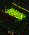
The route via Bolton is a shorter route, however it is much more congested with slow freight trains especially just south of Bolton where the Concentration Yard joins the main line over a flat junction. Also the stations which the express service stops at are much larger (all in towns of 3000+ people) whereas the only station with long enough platforms on the other route is Bolton which has a population of ~700, another problem would be that the service would have to change direction at Gillingham which wouldn't be ideal in real life for such a (relatively short) journey another reason is that the Bolton line is up against the edge of the map and Chippenham is on the shores of the sea hence above there there is no need for passengers, unlike Camberley which when expansion occurs will be the point where passengers come into and out of the southern network penninsula. Hopefully I can do some more today, I might also jump it forwards another 5 years as I am using Chill's patchpack which means that a year can last a very very long time.

-
MetGreatCentral

- Engineer

- Posts: 29
- Joined: 14 Aug 2011 13:10
- Location: London, UK
Re: Show us your network maps
Hi there! Joined this forum primarily to posts screenshots and network maps, so here is mine!
Royal Railways
The company was set up in 1920 by The Crown to accelerate economic growth of the Kingdom.
This is how the network looks after the building of the first InterCity Line, the Eastern, in 1934.
Royal Railways
The company was set up in 1920 by The Crown to accelerate economic growth of the Kingdom.
This is how the network looks after the building of the first InterCity Line, the Eastern, in 1934.
- Attachments
-
- Transport Committee_B.pdf
- Royal Railways Map 1934
- (21.91 KiB) Downloaded 600 times
-
welshdragon
- Tycoon
- Posts: 2148
- Joined: 27 Jul 2007 15:45
- Location: Sunny Wales, Boyo!
- Contact:
Re: Show us your network maps
One from a recent network game:

Re: Show us your network maps
Nice one. What software did you use for that?
*** Ce French Train Set ***
*** Visit my transport related pictures on Flickr ***


Llanfairpwllgwyngyllgogerychwyrndrobwllllantysiliogogogoch
"A committee is a group of men who individually can do nothing but as a group decide that nothing can be done" (Fred Allen 1894-1956 US radio comic).
*** Visit my transport related pictures on Flickr ***
Llanfairpwllgwyngyllgogerychwyrndrobwllllantysiliogogogoch
"A committee is a group of men who individually can do nothing but as a group decide that nothing can be done" (Fred Allen 1894-1956 US radio comic).
-
welshdragon
- Tycoon
- Posts: 2148
- Joined: 27 Jul 2007 15:45
- Location: Sunny Wales, Boyo!
- Contact:
Re: Show us your network maps
Railway Operations Simulator. I'm looking at taking over the development as the guy who started it has stopped, even though the app has so much potential!

Re: Show us your network maps
Like this one I made...
- Attachments
-
- RailwayImage 22-09-2011 12.36.16; Canpool Transport.jpg
- (178.63 KiB) Downloaded 2 times
Last known as: Weirdy
-
welshdragon
- Tycoon
- Posts: 2148
- Joined: 27 Jul 2007 15:45
- Location: Sunny Wales, Boyo!
- Contact:


Re: Show us your network maps
I'm loving this one! Plus Ashington finally has a railway service!t_blast wrote:Hi all,
Long-time lurker just turned mapmaker... I hope you like this effort.
It's very early days on the North Eastern Railway. The moneymakers (three coal and one wood/goods route) are not shown, because I'm mostly into passenger traffic. As it's only 1843, 13 years in, there's not that much passenger traffic out there, but it's building slowly and turning a decent profit in spite of the best efforts of my Planet 2-2-0s!
I'm really into 1980s British Rail and this is the style I'm hoping to emulate - a very anachronistic map style at the moment
Best,
Toni
Best thread ever: Network maps
Loco Scenarios: Caladras Coal - (870) Wessex - (225) Anduin Valley - (245) Sinclaire - (150) The Aural Sea - (200)
Westward Ho! - (475)
Loco Scenarios: Caladras Coal - (870) Wessex - (225) Anduin Valley - (245) Sinclaire - (150) The Aural Sea - (200)
Westward Ho! - (475)
-
Norfolkadam

- Engineer
- Posts: 77
- Joined: 11 Jun 2010 19:16
- Location: Norfolk, UK
- Contact:
Re: Show us your network maps
I hate that this thread has died so here's something to revive it:
It's a map for services surrounding one of 4 major cities in this scenario. I'd like to think it's quite realistic to the British style I'm trying to emulate. Made on Adobe Illustrator.
It's a map for services surrounding one of 4 major cities in this scenario. I'd like to think it's quite realistic to the British style I'm trying to emulate. Made on Adobe Illustrator.
Helmland - The English and Danish island in the North Sea
-
Supercheese
- Tycoon
- Posts: 1660
- Joined: 16 Dec 2007 22:24
- Location: Idaho, USA
Re: Show us your network maps
Nicely done.Norfolkadam wrote:I hate that this thread has died so here's something to revive it:
It's a map for services surrounding one of 4 major cities in this scenario. I'd like to think it's quite realistic to the British style I'm trying to emulate. Made on Adobe Illustrator.
Eyecandy Road Vehicles | Fake Subways | Supercheese's NewObjects
"Fashions and cultures change, but steam trains shall always be majestic."
-Professor Hershel Layton
"Fashions and cultures change, but steam trains shall always be majestic."
-Professor Hershel Layton


Re: Show us your network maps
If only Oxford and Ipswich were that close together IRL 
Nicely done map though ^^
Edit:
Also adding some content...
Nicely done map though ^^
Edit:
Also adding some content...
- Attachments
-
- GreyWolfTransport_v1.24.png
- (645.34 KiB) Downloaded 2 times
Ex TTDPatch Coder
Patch Pack, Github
Patch Pack, Github

Re: Show us your network maps
Here's a little something from my current game - it is 1921 and we have a map of the metro tram system in Kirkburton, which is the largest conurbation on the map. Kirkburton station is the largest station with 5 platforms and is a major hub for Great Eastern Railway services to the south, west and north as well as being the northern terminus for SR's Southern Main Line.
- Attachments
-
- kirkshire tramways map final.jpg
- (1.32 MiB) Downloaded 2 times
-
Norfolkadam
- Engineer
- Posts: 77
- Joined: 11 Jun 2010 19:16
- Location: Norfolk, UK
- Contact:
Re: Show us your network maps
Another map from the same region. This time it's my InterCity network which is operated by 100mph EMUs on the 'vanilla' trunk lines and 187mph sets on the three express lines.
Hope you enjoy, some constructive criticism might be good as I've never had much feedback on my maps.
Hope you enjoy, some constructive criticism might be good as I've never had much feedback on my maps.
Helmland - The English and Danish island in the North Sea
Who is online
Users browsing this forum: No registered users and 4 guests