Page 20 of 36
Re: Screenshot Of The Month Competition - June 2021
Posted: 02 Jul 2021 11:30
by fridaemon
you can see it here:

- ff7rTLn - Imgur.gif (21.68 MiB) Viewed 5711 times
Video
here.
Re: Screenshot Of The Month Competition - June 2021
Posted: 02 Jul 2021 11:41
by wallyweb
Taschi wrote: 02 Jul 2021 11:08
But only in straiggt lines and without stops so they're not really useful as subway systems.
Diagonal would be nice, but not critical.
Underwater stops are not realistic hence they are not necessary. (where would the cargo go?)
Also, even vanilla OpenTTD allows tunnels under water, unless that water isn't an ocean.
Rivers and canals are built on land, so a normal tunnel will do the job.
Still, your points are well taken and worth consideration.
Re: Screenshot Of The Month Competition - June 2021
Posted: 02 Jul 2021 12:03
by Taschi
wallyweb wrote: 02 Jul 2021 11:41
Underwater stops are not realistic hence they are not necessary. (where would the cargo go?)
My point here is that the biggest problem for subways in OpenTTD is that every station has to be above ground, taking up space and requiring massive destruction of city buildings. A subway with stations that are bidden underwater (at the shore, of course) could somewhat mitigate that problem.
But I still do think it's a dirty hack and while doing dirty hacks, you might as well just use the "Fake Subways" NewGRF.
Re: Screenshot Of The Month Competition - June 2021
Posted: 02 Jul 2021 12:27
by GarryG
The subway idea needs some thinking and if if be worth trying.
Taschi wrote: 02 Jul 2021 12:03
My point here is that the biggest problem for subways in OpenTTD is that every station has to be above ground, taking up space and requiring massive destruction of city buildings. A subway with stations that are bidden underwater (at the shore, of course) could somewhat mitigate that problem.
A station to appear and subway tracks that is to look like it is underwater would probably need to be built same way as the seaport airport. Close to the shore and have a non-track station tile to go on the shore such as a set of subway stairs. Most of it would be a optical allusion and boats will not be able to pass over it.
Sorry Wallyweb we clogging up your screenshot competition forum.

Re: Screenshot Of The Month Competition - June 2021
Posted: 02 Jul 2021 14:20
by wallyweb
GarryG wrote: 02 Jul 2021 12:27
Sorry Wallyweb we clogging up your screenshot competition forum.
Quite! Van Horne says you should move along. Foreman says don't get your feet wet.

Re: Screenshot Of The Month Competition - June 2021
Posted: 06 Jul 2021 13:13
by wallyweb
TIME'S UP !!!
Congratulations to fridaemon
A PM has been sent.
Re: Screenshot Of The Month Competition - July 2021
Posted: 06 Jul 2021 14:58
by wallyweb
We have a reply from
fridaemon and a new theme for
July 2021 
...
THE INDUSTRIAL ZONE
Get your tools out and start manufacturing your screenshots.

Re: Screenshot Of The Month Competition - July 2021
Posted: 11 Jul 2021 01:40
by ebla71
wallyweb wrote: 06 Jul 2021 14:58
THE INDUSTRIAL ZONE
Even today, the
Ruhr area is still the
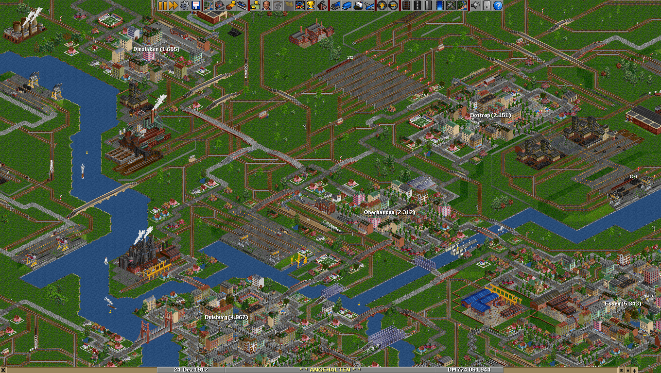
largest industrial zone in Germany. This screenshot, however, takes you back to the year 1912 and shows in the lower left part the joining of the Ruhr river with the Rhine. Major steelworks, coal mines, and coke plants are found along both rivers and at the bottom right is the cast iron factory of Fried. Krupp where almost a century earlier the industrial history of the area started. Accidentally (and I really did not plan this) the picture - possibly shot from a balloon or maybe an early zeppelin - was taken on December 24th 1912 but there is no snow as is quite regular in the area, even before anybody ever got concerned about too much carbon dioxide in the atmosphere - and as you can see, the factories, steamships, and locomotives are very busy producing it.
Cities and major railway lines are placed as closely as possible to their correct geographical locations but some industrial lines might be missing (otherwise I'd have to go to a 4096x4096 map or even larger
)
Re: Screenshot Of The Month Competition - July 2021
Posted: 20 Jul 2021 14:11
by gravelpit
This is the bottom of my main NANTLEY town and my current scenario.
This zone consists of the Hump Yard from the right which accepts and returns 10 cargo.
DTC port with Bulk terminal and Chemicals modeled a bit after (BASF Ludwigshafen).
The zone serves the entire region, enjoy your viewing.

- test.jpg (98.69 KiB) Viewed 5231 times
Re: Screenshot Of The Month Competition - July 2021
Posted: 22 Jul 2021 17:45
by DemianWSE
Hi everyone! Here's my screenshot for this month:
A dense industrial zone between the cities of Brunton and Slaninghall. Iron ore and limestone mines, a blast furnace and a basic oxygen furnace, along with many truck stops, train platforms, depots, sidings and docks, and a high-speed passenger line running right through the middle.

Re: Screenshot Of The Month Competition - July 2021
Posted: 25 Jul 2021 17:02
by wallyweb
Here is my entry. We will see you when the sun sets on Wednesday on Baker Island.
In 1920 a band of Canadian malcontents settled on the Isle of X and sowed the seeds of an economical wonder. They established and formed the local authorities of 25 towns of which the central 9 were to be free of industries while they noted that the perimeter of the island was rich in resources. They commissioned Citiscape Tramsit Company (CTC) to put a plan into action. CTC quickly determined that the 16 towns outside the central 9 were to form an industrial zone. The results were quite extraordinary and the rest is history.

Re: Screenshot Of The Month Competition - July 2021
Posted: 26 Jul 2021 19:32
by fridaemon
Re: Screenshot Of The Month Competition - July 2021
Posted: 26 Jul 2021 19:54
by wallyweb
Re: Screenshot Of The Month Competition - July 2021
Posted: 26 Jul 2021 19:59
by Erato
The Kashihara Abura Emporium, home to my region's entire chemical industry. Who needs crude oil when you have soy beans?

Re: Screenshot Of The Month Competition - July 2021
Posted: 26 Jul 2021 20:06
by fridaemon
Erato wrote: 26 Jul 2021 19:59
Guys, these details

Love it!
Re: Screenshot Of The Month Competition - July 2021
Posted: 26 Jul 2021 22:22
by OzTrans
Industrial Zone of Metropolitano ...
Re: Screenshot Of The Month Competition - July 2021
Posted: 27 Jul 2021 05:00
by flogeza
From the JGR Discord server: San José Plantation
Re: Screenshot Of The Month Competition - July 2021
Posted: 27 Jul 2021 21:34
by Fredinho
Lots of lovely entries! I started working on mine, but unfortunately I find myself in the middle of a road trip, so I won't be able to make it to the deadline. The best of luck!
Re: Screenshot Of The Month Competition - July 2021
Posted: 29 Jul 2021 11:00
by wallyweb
That thief Mr.International Dateline has done it again, this time making off with our last Wednesday in July 2021, leaving this note nailed to a coconut palm:
SUBMISSIONS ARE CLOSED
bwahahahaaaaaa ....
with the poll candidates listed below ...
DemianWSE wrote:A dense industrial zone between the cities of Brunton and Slaninghall. Iron ore and limestone mines, a blast furnace and a basic oxygen furnace, along with many truck stops, train platforms, depots, sidings and docks, and a high-speed passenger line running right through the middle.

ebla71 wrote:Even today, the Ruhr area is still the largest industrial zone in Germany. This screenshot, however, takes you back to the year 1912 and shows in the lower left part the joining of the Ruhr river with the Rhine. Major steelworks, coal mines, and coke plants are found along both rivers and at the bottom right is the cast iron factory of Fried. Krupp where almost a century earlier the industrial history of the area started. Accidentally (and I really did not plan this) the picture - possibly shot from a balloon or maybe an early zeppelin - was taken on December 24th 1912 but there is no snow as is quite regular in the area, even before anybody ever got concerned about too much carbon dioxide in the atmosphere - and as you can see, the factories, steamships, and locomotives are very busy producing it.
Cities and major railway lines are placed as closely as possible to their correct geographical locations but some industrial lines might be missing (otherwise I'd have to go to a 4096x4096 map or even larger
)

Erato wrote:The Kashihara Abura Emporium, home to my region's entire chemical industry. Who needs crude oil when you have soy beans?
flogeza wrote:From the JGR Discord server: San José Plantation

fridaemon wrote:Let me introduce you to one of my industrial area and, of course, new warehouses

gravelpit wrote:This is the bottom of my main NANTLEY town and my current scenario.
This zone consists of the Hump Yard from the right which accepts and returns 10 cargo.
DTC port with Bulk terminal and Chemicals modeled a bit after (BASF Ludwigshafen).
The zone serves the entire region, enjoy your viewing.

OzTrans wrote:Industrial Zone of Metropolitano ...

wallyweb wrote:In 1920 a band of Canadian malcontents settled on the Isle of X and sowed the seeds of an economical wonder. They established and formed the local authorities of 25 towns of which the central 9 were to be free of industries while they noted that the perimeter of the island was rich in resources. They commissioned Citiscape Tramsit Company (CTC) to put a plan into action. CTC quickly determined that the 16 towns outside the central 9 were to form an industrial zone. The results were quite extraordinary and the rest is history.
Re: Screenshot Of The Month Competition - July 2021
Posted: 29 Jul 2021 11:03
by Taschi
Some very tough competition this month.