Page 20 of 31
Re: STD screenshots
Posted: 25 Sep 2015 04:14
by STD
DanMacK wrote:Loving the screenshots

What Road Veh set is that BTW?
Thank You, DanMacK
. Yesterday I was looking for an answer to your question. Yet could not find. You please drop a screenshot here on the forum. Other sets except those in the screenshot, I have not used

.

- GRF's - 10.11.1926.png (24.67 KiB) Viewed 1666 times
Re: STD screenshots
Posted: 28 Sep 2015 14:22
by STD
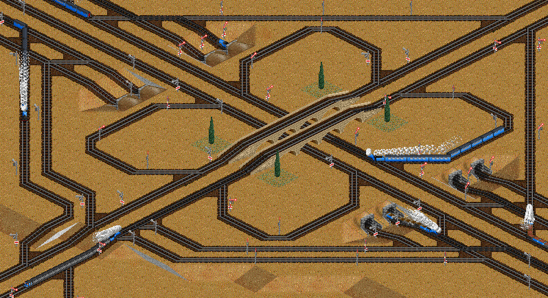
Another screenshot from the game (26 April 1928). I upgraded railway junction near a large city. Now the trains do not create congestion near the stations and on corners.
Re: STD screenshots
Posted: 30 Sep 2015 06:36
by STD
GIF image from the game. I tried the program GifCam. Loved to use. And most importantly is not difficult
.

- tropic GIF_1.gif (23.44 MiB) Viewed 3621 times
Re: STD screenshots
Posted: 30 Sep 2015 08:11
by arikover

That's great!
Re: STD screenshots
Posted: 30 Sep 2015 09:20
by STD
Thank you, arikover
. Here's another did. I really liked it

.
- The movement of trains through a major rail junction
- tropic GIF_2.gif (1.82 MiB) Viewed 3603 times
- Cargo port

- tropic GIF_3.gif (10.46 MiB) Viewed 3603 times
- Passenger station Nenham
- tropic GIF_4.gif (17.67 MiB) Viewed 3603 times
Re: STD screenshots
Posted: 08 Oct 2015 16:43
by STD
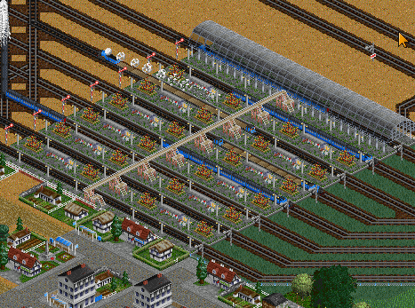
I soon plan to start a new game. Here decided to show road junction, which I want to use in the next game. I'm curious to know the opinion of players. Which junction were you trying to create?
Another question: have you tried to create road junctions, such as those that are in real life at least approximately?

Re: STD screenshots
Posted: 08 Oct 2015 16:45
by STD
Re: STD screenshots
Posted: 09 Oct 2015 00:12
by kamnet
STD wrote:Another question: have you tried to create road junctions, such as those that are in real life at least approximately?
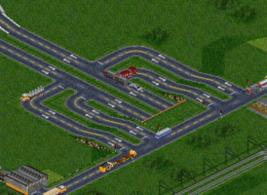
I do it every once in awhile if I really have enough vehicle traffic to merit doing so. From my big game I ran a few years ago, here's a screenshot of a 4-lane highway I built that runs underneath a mountain, with off-ramps to a road that runs over it.
Re: STD screenshots
Posted: 09 Oct 2015 08:07
by Pyoro
A good roadnetwork is just as important as a good rail network for a nice game, if you ask me; so
of course
I usually try to keep them simple, though -
http://www.tt-forums.net/viewtopic.php? ... 0#p1131629
If they're too big I find that RVs don't really use them. Too many detours for the pathfinder ^^
Re: STD screenshots
Posted: 09 Oct 2015 17:40
by S-Transport
I usually do not build a big road network, because I often only build a railway and a tram network. I want to see rails... And I do not know any bus station replacement set.
The railway live!
Re: STD screenshots
Posted: 17 Oct 2015 11:57
by STD
Thank you all for the answers
. I realized that most of the players make a complex Railway junction. And the rest of the transport (trucks, ships, trams, trolleybuses) in the game is secondary. I personally do not always put emphasis on road transport. As kamnet said, it depends on the amount of transport used.
I create a new scenario that used a height map - Ukraine (2048 x 1024)
. Now placed all the cities according to their real location. The only drawback - all the cities are written in Russian. To me it's more convenient to do. In the near future I plan to place industrial enterprises, FIRS I am using 1.4.4. Version of the game - OpenTTD Patchpack Spring2013 v2.2.192 Full win32.
Here is a screenshot of the map:
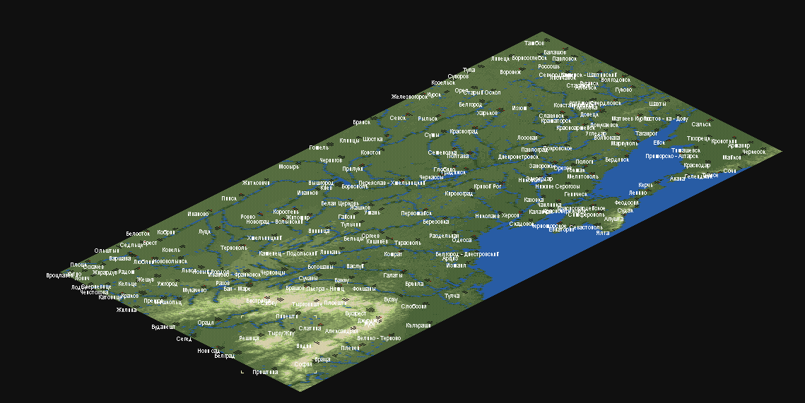
- Ukraine_subarctic_2048x1024_01.01.1950.png (71.34 KiB) Viewed 1666 times
Start date of the game can be any, but I will start with 1.01.1950. I will use Polish and Dutch sets of trains.
Soon I will show more information.
Re: STD screenshots
Posted: 23 Oct 2015 11:31
by STD
I continue to add information about the new scenario:
To start the list of the graphics used

- grf_subarctic.png (30.23 KiB) Viewed 1666 times
The list is quite big since I will use almost all of the graphics, almost all the sets of stations (passenger and freight), just two sets of trains (Polish and Dutch), nutracks, Swedish Houses (the most suitable set for this scenario in my opinion) and other grf's. I plan to replace sets of trains one - xUSSR railway set. At this point is not finally decided yet.
The script itself includes the following countries: Ukraine, Western Russia, Moldova, Romania, Eastern Poland, part of Hungary, part of Bulgaria and part of Slovakia. For me, a very large area for future games.
At the moment the recommended build of OpenTTD - OpenTTD Patchpack Spring2013 v2.2.192 Full win32.
I still do a lot of work on the accommodation on a map in different enterprises. While completely ready with the enterprises of the Crimea, Northern Black sea and Azov sea, the Azov sea coast.
I also want to show a recreation area for tourists in the mountainous part of the Crimea
. I used the infrastructure of TARS (the latest version, thank you very much for this SwissFan91)
Tourists love to ski and snowboard on the slopes of the mountains. There are a few different routes for beginners and professionals.
Re: STD screenshots
Posted: 23 Oct 2015 11:45
by STD
General view of the ski slopes in the Crimea

- 3_subarctic.png (178.01 KiB) Viewed 1666 times
I also plan to do the ski slopes in the Carpathians with all the necessary infrastructure TARS.
And also plan to build ski slopes in the Caucasus. It'll be three main ski resorts in the region.
I have in each city there is a hotel, prodovolstenny store, in all the major cities built filling station and a dump nearby.
I like to do this scenario. While is nice though and need a lot time to complete
.
Soon there will be screenshots on the scenario and other information. In the future, will show areas of industry, agriculture, mining.
Re: STD screenshots
Posted: 26 Oct 2015 13:32
by STD
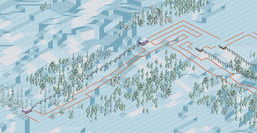
Decided to show a ski infrastructure in the resorts of the South of Russia
The first track near the city of Gelendzhik

- 5_subarctic.png (174.08 KiB) Viewed 3089 times
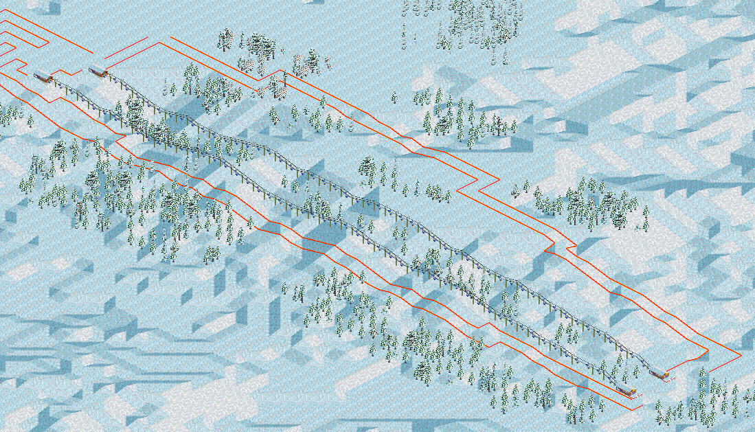
The second larger ski slope is located near the city of Sochi

- 6_subarctic.png (232.59 KiB) Viewed 3089 times
For accommodation of tourists was built hotel

- 7_subarctic.png (173.98 KiB) Viewed 3089 times
Soon the scenario will be ready. I still have a bit left to do
.
I replaced the Polish and the Dutch train set for xUSSR Railway set.
Re: STD screenshots
Posted: 26 Oct 2015 19:52
by Ameecher
They're some pretty savage cross-country runs you've got there.
Re: STD screenshots
Posted: 27 Oct 2015 23:38
by SwissFan91
Ameecher wrote:They're some pretty savage cross-country runs you've got there.
Indeed. One thing I enjoy about building my pistes in OTTD is making sure that there are very little uphill tiles (unless preceded by a few downhill ones) and making sure all the lifts are accessible. More advanced planning comes in making sure a 'green' easy slope leads down from most lifts to make sure those noobs aren't left out!
Re: STD screenshots
Posted: 29 Oct 2015 15:10
by STD
Thanks for the explanation, SwissFan91. Personally I like to use TARS
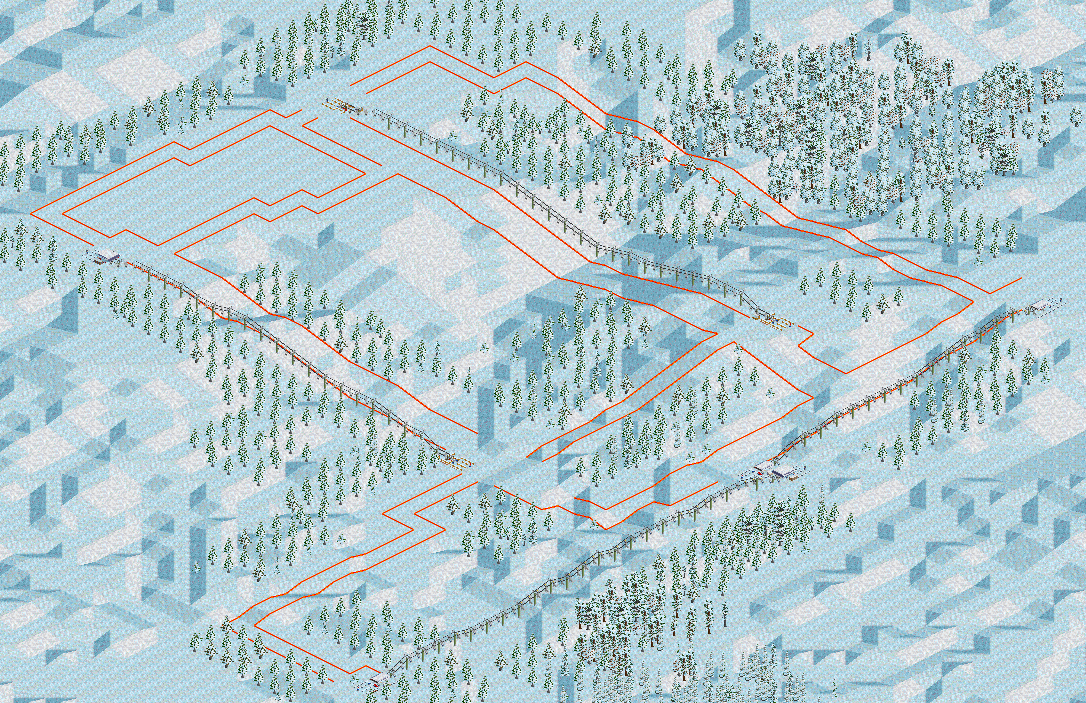
Here's another location for the ski slopes of the Carpathian mountains

- The location of slopes in the Carpathian mountains.png (107.01 KiB) Viewed 1666 times
I created four zones (see screenshots below). The Northern part of the Carpathians
The Western part
- 9_subarctic.png (189.68 KiB) Viewed 1666 times
Re: STD screenshots
Posted: 29 Oct 2015 15:14
by STD
The Western part
- 10_subarctic.png (313.14 KiB) Viewed 1666 times
The Central part of the Carpathians
- 11_subarctic.png (372.18 KiB) Viewed 1666 times
The Eastern part of the Carpathians
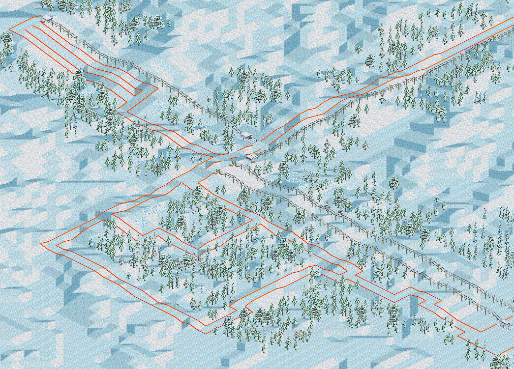
- 12_subarctic.png (434.55 KiB) Viewed 1666 times
Re: STD screenshots
Posted: 29 Oct 2015 15:37
by STD
The Eastern part of the Carpathians

- 13_subarctic.png (424.34 KiB) Viewed 1666 times
I decided on the list grf's files in scripts. Removed Japanese set stations, Polish and Dutch set of train, metro track, added xUSSR Railway set.
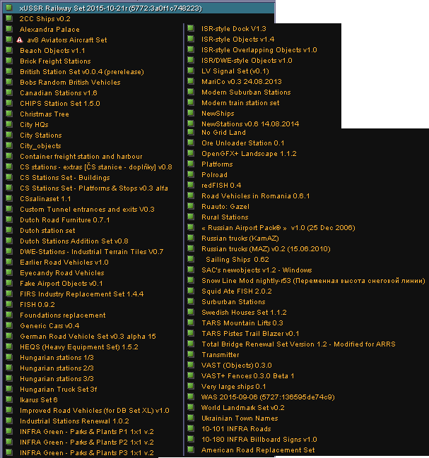
- grf_subarctic_final_version.png (30.7 KiB) Viewed 1666 times
Today I finished making the scenario. Here is the final version.
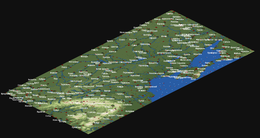
- Map region.png (72.89 KiB) Viewed 1666 times
One drawback - the names of cities are written in Russian. If you want to play in this scenario, I think that this should not prevent
In the next version of the scenario I will remove more than half grf's files, I will leave only the most necessary.
The complete scenario
Hooray, I reached a status on the forum - Tycoon.
Re: STD screenshots
Posted: 29 Oct 2015 18:20
by S-Transport
I do not think, that I will play with the scenario, but reading of Russian town names would not be the problem...
But looks nice!