That's a very nice map design you've got there; simple yet elegant. How'd you make it?JGR wrote:Here's a network map from my current game. Whilst I've not finished the game, it's probably not going to change too dramatically from this.
I've been working on this on and off for a while now so thought I ought to get round to posting it.
Show us your network maps
Re: Show us your network maps


Re: Show us your network maps
Many thanks :3JDCollie wrote:That's a very nice map design you've got there; simple yet elegant. How'd you make it?JGR wrote:Here's a network map from my current game. Whilst I've not finished the game, it's probably not going to change too dramatically from this.
I've been working on this on and off for a while now so thought I ought to get round to posting it.
I used MS Visio 2003.
Ex TTDPatch Coder
Patch Pack, Github
Patch Pack, Github
Re: Show us your network maps
Huh, I've never heard of that until now. I'll have to check it out!JGR wrote: Many thanks :3
I used MS Visio 2003.
Re: Show us your network maps
Here is a map I made yesterday for a long running game where I restricted myself to passenger transportation.
Here is a PNG rendering of the SVG:
Here is a PNG rendering of the SVG:
-
S-Transport
- Chief Executive

- Posts: 748
- Joined: 25 Jul 2014 19:35
- Location: Giebichenstein, Germany
Re: Show us your network maps
A text-editor and a lot of patience. I drew a sketch of the map with pencil and recreated that drawing as an SVG by manually specifying all the coordinates.S-Transport wrote:What is that made with?
-
jegerpizza

- Engineer

- Posts: 19
- Joined: 27 Feb 2013 14:11
- Location: Finland + Denmark
- Contact:
Re: Show us your network maps
Here a little map over the passenger train services in one of my games. I used http://beno.org.uk/metromapcreator/# to make it 
And i could not stop my self for posting Reading station.

Due to me building much. I done a new map.

And i could not stop my self for posting Reading station.
Due to me building much. I done a new map.
Last edited by jegerpizza on 25 Nov 2014 12:48, edited 3 times in total.

Re: Show us your network maps
That's a cool tool actually. Very nice. I will give this one a go for my next project
*** Ce French Train Set ***
*** Visit my transport related pictures on Flickr ***


Llanfairpwllgwyngyllgogerychwyrndrobwllllantysiliogogogoch
"A committee is a group of men who individually can do nothing but as a group decide that nothing can be done" (Fred Allen 1894-1956 US radio comic).
*** Visit my transport related pictures on Flickr ***
Llanfairpwllgwyngyllgogerychwyrndrobwllllantysiliogogogoch
"A committee is a group of men who individually can do nothing but as a group decide that nothing can be done" (Fred Allen 1894-1956 US radio comic).
Re: Show us your network maps
This is the map from a german Multiplayergame.

Ingamevideos from "Böblingen" and "Bad Brückenau" as big railnodes.
http://youtu.be/f4cIlZIuvOQ?list=UUVlJS ... qzBx-80D1Q
http://youtu.be/MLioXeo9krw?list=UUVlJS ... qzBx-80D1Q
Topic to this game (but in german)
http://www.tt-ms.de/forum/showthread.php?tid=6407
Ingamevideos from "Böblingen" and "Bad Brückenau" as big railnodes.
http://youtu.be/f4cIlZIuvOQ?list=UUVlJS ... qzBx-80D1Q
http://youtu.be/MLioXeo9krw?list=UUVlJS ... qzBx-80D1Q
Topic to this game (but in german)
http://www.tt-ms.de/forum/showthread.php?tid=6407
Re: Show us your network maps
Network map from my current game
I used MS Visio for this one. It covers about one third of a 512x512 sized map, so there is still room for improvement and more lines

I used MS Visio for this one. It covers about one third of a 512x512 sized map, so there is still room for improvement and more lines
-
SztruksowyCzłowiek
- Engineer
- Posts: 2
- Joined: 21 Nov 2014 14:50
Re: Show us your network maps
I made a map of my network using, as you recommended, Dia. I also made another one using the Metro Map creator. It's a British Isles scenario beginning in 1935, and the maps show my network in January 1944
- Attachments
-
- STCsty1949.png
- The Dia version. Red arrows are the London City Circle, while the green arrows are bus lines.
- (310.14 KiB) Downloaded 6 times
-
- STCsty1949mmc.png
- The simpler version.
- (34.43 KiB) Downloaded 6 times

Re: Show us your network maps
Its pretty nifty, although I found it gets a bit unwieldly when the map is larger/more complicated. I also ran into a problem exporting a whole high detail file, and thus had to stitch together a few lower detail files to create mine.The Irish wrote:That's a cool tool actually. Very nice. I will give this one a go for my next project
- Attachments
-
- network map.png
- (792.8 KiB) Downloaded 6 times


Re: Show us your network maps
Unless you've got multiple "Tring"s in the game, I suspect that map may be a little unrealistic...Chris wrote:Its pretty nifty, although I found it gets a bit unwieldly when the map is larger/more complicated. I also ran into a problem exporting a whole high detail file, and thus had to stitch together a few lower detail files to create mine.The Irish wrote:That's a cool tool actually. Very nice. I will give this one a go for my next project
Re: Show us your network maps
Haha good spot, I think the one on the black line should be Rotherham. There's also Hastings Piccadillu and winchesster...Pingaware wrote:Unless you've got multiple "Tring"s in the game, I suspect that map may be a little unrealistic...
-
SztruksowyCzłowiek
- Engineer
- Posts: 2
- Joined: 21 Nov 2014 14:50
Re: Show us your network maps
A mashup of the Metro Map Creator (http://beno.org.uk/metromapcreator/#) and MS Paint (logo). Somehow, it looks quite good.
- Attachments
-
- STC mapa 1964.png
- (719.87 KiB) Downloaded 4 times
-
- This happens when you set the curves to 100.
- MMC100.PNG (84.82 KiB) Viewed 3773 times
Re: Show us your network maps
Sorry to bump this thread from the dead but I have a question for the cartographers of the OTTD community:
What's the best way to scale things? I'm trying to map out one of the major metropolitan areas in my current game but the mix of regional and intercity trains mixed in with trams has really confused me.
What's the best way to scale things? I'm trying to map out one of the major metropolitan areas in my current game but the mix of regional and intercity trains mixed in with trams has really confused me.
Re: Show us your network maps
It's probably best not to try to make your map "to scale", it generally makes more sense to try to make it topologically representative. Don't be afraid to drastically expand complex areas to give you more room to make things look neat and uncluttered.SNCF wrote:Sorry to bump this thread from the dead but I have a question for the cartographers of the OTTD community:
What's the best way to scale things? I'm trying to map out one of the major metropolitan areas in my current game but the mix of regional and intercity trains mixed in with trams has really confused me.
Also, you could use different colour or thickness of line to indicate local services/trams, and you could use a smaller font for the names of local tram stops.
Ex TTDPatch Coder
Patch Pack, Github
Patch Pack, Github
Re: Show us your network maps
Thanks for the tips!JGR wrote:It's probably best not to try to make your map "to scale", it generally makes more sense to try to make it topologically representative. Don't be afraid to drastically expand complex areas to give you more room to make things look neat and uncluttered.SNCF wrote:Sorry to bump this thread from the dead but I have a question for the cartographers of the OTTD community:
What's the best way to scale things? I'm trying to map out one of the major metropolitan areas in my current game but the mix of regional and intercity trains mixed in with trams has really confused me.
Also, you could use different colour or thickness of line to indicate local services/trams, and you could use a smaller font for the names of local tram stops.


Re: Show us your network maps
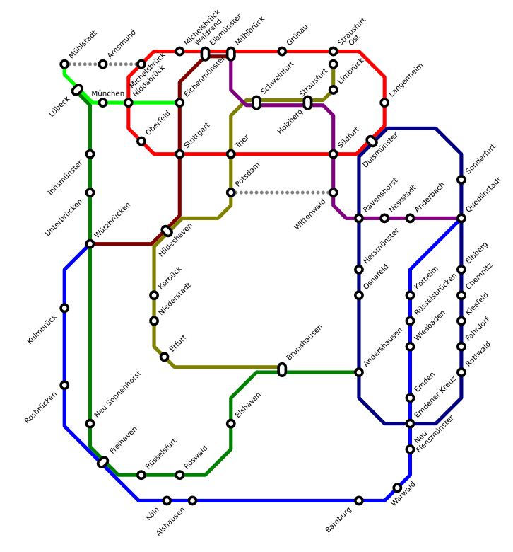
Okay, so, here is my a network map from my most recent game. It's a German Game, and this is the S-Bahn Network for the City of Northeim. The Map itself is in a combination of both German and English. (Please excuse the German, I'm not sure as to how good it is, I used Google Translate!  )
)
- Attachments
-
- Northeim S-Bahn.png
- (341.79 KiB) Not downloaded yet
-
S-Transport
- Chief Executive
- Posts: 748
- Joined: 25 Jul 2014 19:35
- Location: Giebichenstein, Germany
Re: Show us your network maps
Very nice! And the German sentences correctly: „Alle grauen Linien und Bahnhöfe dienen nur dem Regional- und Intercity-Verkehr der Deutschen Bahn“ and „ICE-Züge zurzeit an diesem Bahnhof ausgesetzt“. „Bauarbeiten im Gange“ is correct German, but „im Bau“ would normally be used, I think.
Greetings, S-Transport
My pictures
My pictures
Who is online
Users browsing this forum: No registered users and 3 guests