
Ok. I tried to find something better:jor[D]1 wrote:Nice, but would go for a better readable font.
Show us your network maps
Re: Show us your network maps
- Attachments
-
- Air Lumiere Network 3.png (256.19 KiB) Viewed 3546 times
*** Ce French Train Set ***
*** Visit my transport related pictures on Flickr ***


Llanfairpwllgwyngyllgogerychwyrndrobwllllantysiliogogogoch
"A committee is a group of men who individually can do nothing but as a group decide that nothing can be done" (Fred Allen 1894-1956 US radio comic).
*** Visit my transport related pictures on Flickr ***
Llanfairpwllgwyngyllgogerychwyrndrobwllllantysiliogogogoch
"A committee is a group of men who individually can do nothing but as a group decide that nothing can be done" (Fred Allen 1894-1956 US radio comic).

Re: Show us your network maps
MS Power Point.
*** Ce French Train Set ***
*** Visit my transport related pictures on Flickr ***
Llanfairpwllgwyngyllgogerychwyrndrobwllllantysiliogogogoch
"A committee is a group of men who individually can do nothing but as a group decide that nothing can be done" (Fred Allen 1894-1956 US radio comic).
*** Visit my transport related pictures on Flickr ***
Llanfairpwllgwyngyllgogerychwyrndrobwllllantysiliogogogoch
"A committee is a group of men who individually can do nothing but as a group decide that nothing can be done" (Fred Allen 1894-1956 US radio comic).
Re: Show us your network maps
My first try on Network maps..... Using MS Paint
Using local resources to made this...
Using local resources to made this...
YNM = yoursNotMine - Don't get it ?
「ヨーッスノットマイン」もと申します。
「ヨーッスノットマイン」もと申します。


Re: Show us your network maps
Lol. Nice one!Yoursnotmine wrote:My first try on Network maps..... Using MS Paint
Using local resources to made this...
Best thread ever: Network maps
Loco Scenarios: Caladras Coal - (870) Wessex - (225) Anduin Valley - (245) Sinclaire - (150) The Aural Sea - (200)
Westward Ho! - (475)
Loco Scenarios: Caladras Coal - (870) Wessex - (225) Anduin Valley - (245) Sinclaire - (150) The Aural Sea - (200)
Westward Ho! - (475)
Re: Show us your network maps
I mapped the passenger services in my current game. Road/tram services not shown, because the map would need to be five times as big  .
EDIT: Drawn using Dia, a rather neat GPL program.
.
EDIT: Drawn using Dia, a rather neat GPL program.
- OpenTTD_Map2.png (77.42 KiB) Viewed 11105 times
Temporary Permanent signature filling text. Content coming soon delayed indefinitely! Oh, and I have had a screenshot thread.
Linux user (XMonad DWM/KDE, Arch), IRC obsessive and rail enthusiast. No longer building robots; now I ring church bells.
Author of an incredibly boring stickied post about NewGRFs.
Linux user (XMonad DWM/KDE, Arch), IRC obsessive and rail enthusiast. No longer building robots; now I ring church bells.
Author of an incredibly boring stickied post about NewGRFs.

Re: Show us your network maps
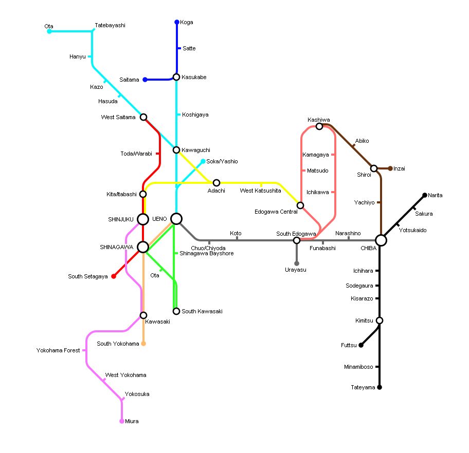
Nihon Works Corp -- Passenger Network 1930
This is from my game in my Kanto Area scenario (which you can find in the scenarios forum)
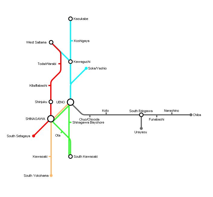
This is from my game in my Kanto Area scenario (which you can find in the scenarios forum)
Last edited by Aerond on 15 Jun 2012 00:56, edited 1 time in total.
Re: Show us your network maps
Nihon Works in 1940
Re: Show us your network maps
Woah woah woah! Intense things Aerond!Aerond wrote:Nihon Works in 1940
Do you have a screenshot thread?
Last edited by bwong on 17 Jun 2012 02:58, edited 1 time in total.
Check out some of my work
-
Norfolkadam

- Engineer

- Posts: 77
- Joined: 11 Jun 2010 19:16
- Location: Norfolk, UK
- Contact:
Re: Show us your network maps
This is what I've been working on this evening. A pretty large conurbation with regional, local and high-speed lines, several major centres of population and two international airports.
I'm pretty happy with it, I think it's fairly realistic which is what I go for.
I'm pretty happy with it, I think it's fairly realistic which is what I go for.
Helmland - The English and Danish island in the North Sea
Re: Show us your network maps
^ I like this very much 
Re: Show us your network maps
dittoGoreiilar wrote:^ I like this very much
Check out some of my work

Re: Show us your network maps
SWEEEEEEET! What software did you use?Norfolkadam wrote:This is what I've been working on this evening. A pretty large conurbation with regional, local and high-speed lines, several major centres of population and two international airports.
I'm pretty happy with it, I think it's fairly realistic which is what I go for.
-
Norfolkadam
- Engineer
- Posts: 77
- Joined: 11 Jun 2010 19:16
- Location: Norfolk, UK
- Contact:
Re: Show us your network maps
Adobe Illustrator.GurraJG wrote:SWEEEEEEET! What software did you use?Norfolkadam wrote:This is what I've been working on this evening. A pretty large conurbation with regional, local and high-speed lines, several major centres of population and two international airports.
I'm pretty happy with it, I think it's fairly realistic which is what I go for.
Thanks for the compliments guys.
Helmland - The English and Danish island in the North Sea
Re: Show us your network maps
Can you upload the illustrator file? I would totally reverse engineer it. (ITS TOO AWESOMENorfolkadam wrote:Adobe Illustrator.GurraJG wrote:SWEEEEEEET! What software did you use?Norfolkadam wrote:This is what I've been working on this evening. A pretty large conurbation with regional, local and high-speed lines, several major centres of population and two international airports.
I'm pretty happy with it, I think it's fairly realistic which is what I go for.
Thanks for the compliments guys.
Check out some of my work
Re: Show us your network maps
Nihon Works in 1950 (had to redo te map to make room at the sides for future expansion)
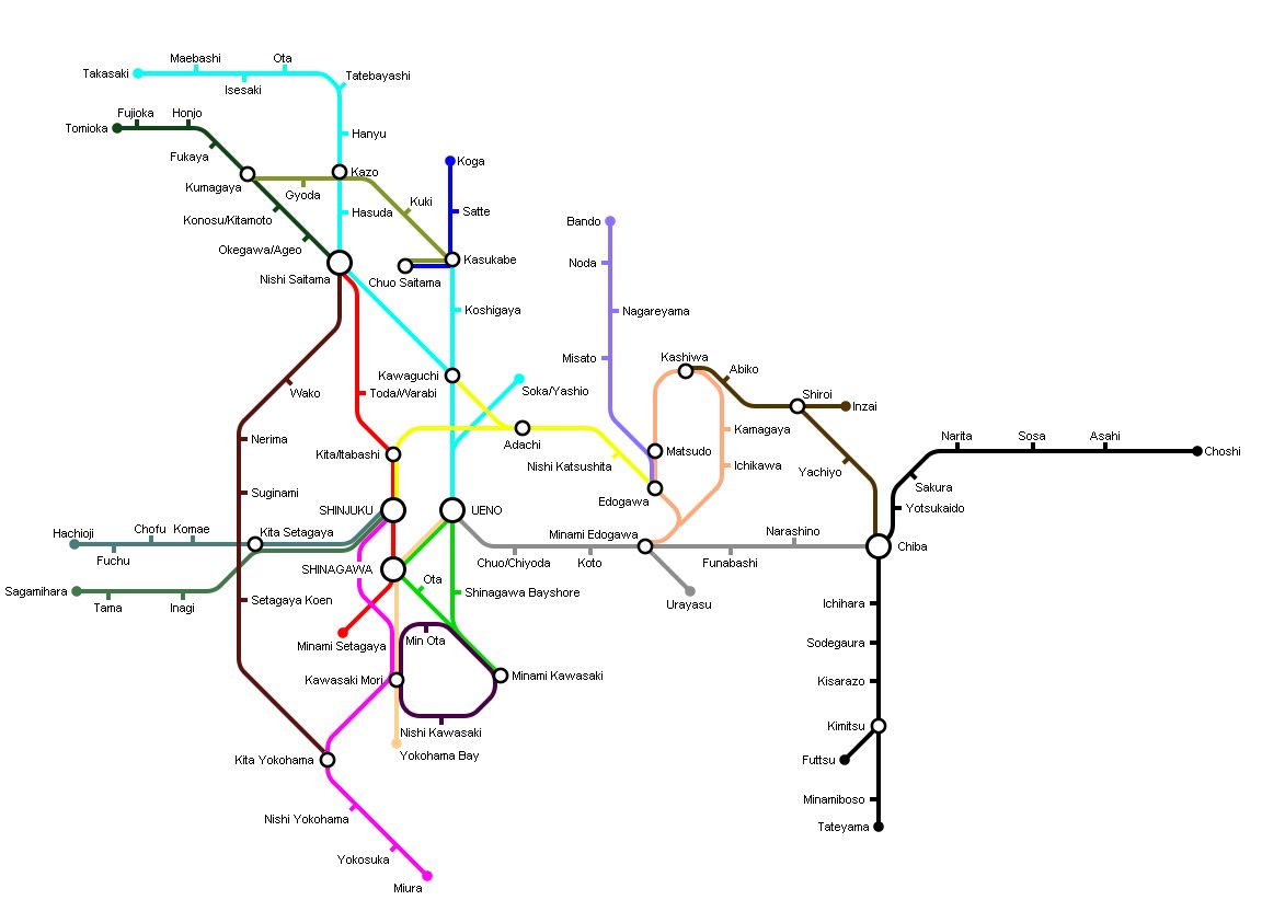
For the next 10 years I plan to start covering the cities of Western Tokyo, start expansion of the network to the NorthEast and expand the Chuo Line from Hachioji to Kofu
For the next 10 years I plan to start covering the cities of Western Tokyo, start expansion of the network to the NorthEast and expand the Chuo Line from Hachioji to Kofu

Re: Show us your network maps
Do you have a Screenshot thread to post Screenies from the Game in? I'd love to see the Network. BTW Happy Birthday.Norfolkadam wrote:This is what I've been working on this evening. A pretty large conurbation with regional, local and high-speed lines, several major centres of population and two international airports.
I'm pretty happy with it, I think it's fairly realistic which is what I go for.
-
Level Crossing
- Tycoon

- Posts: 1187
- Joined: 07 Feb 2011 22:04
- Location: East Coast, United States
Re: Show us your network maps
All I'm missing is the right font...
- Attachments
-
- Made with MS Paint
- Network Map.PNG (36.39 KiB) Viewed 10683 times
Like my avatar? See my screenshot thread
-
Norfolkadam
- Engineer
- Posts: 77
- Joined: 11 Jun 2010 19:16
- Location: Norfolk, UK
- Contact:
Re: Show us your network maps
Attached to this post for you.bwong wrote:Can you upload the illustrator file? I would totally reverse engineer it. (ITS TOO AWESOME)
A321Pilot wrote:Do you have a Screenshot thread to post Screenies from the Game in? I'd love to see the Network. BTW Happy Birthday.
I don't have one at the moment, no, but I might make one tonight or possibly this week at some point. I find it hard to make screenshot threads interesting but we'll see.
Helmland - The English and Danish island in the North Sea
Re: Show us your network maps
I want to make some maps, but what free software should I use. Many are mentioned, but which is best. I don't really want to use MS Paint.
Who is online
Users browsing this forum: No registered users and 17 guests