Page 15 of 19
Re: Show us your network maps
Posted: 26 Apr 2012 17:44
by The Irish
jor[D]1 wrote:Nice, but would go for a better readable font.
Ok. I tried to find something better:
Re: Show us your network maps
Posted: 26 Apr 2012 20:27
by jor[D]1
Nice, which program was used?
Re: Show us your network maps
Posted: 28 Apr 2012 06:11
by The Irish
MS Power Point.
Re: Show us your network maps
Posted: 02 May 2012 12:57
by YNM
My first try on Network maps..... Using MS Paint
Using local resources to made this...

Re: Show us your network maps
Posted: 06 Jun 2012 05:38
by teccuk
Yoursnotmine wrote:My first try on Network maps..... Using MS Paint
Using local resources to made this...
England-Land Map.png
Lol. Nice one!
Re: Show us your network maps
Posted: 09 Jun 2012 12:22
by FLHerne
I mapped the passenger services in my current game. Road/tram services not shown, because the map would need to be five times as big

.

- OpenTTD_Map2.png (77.42 KiB) Viewed 11082 times
EDIT: Drawn using
Dia, a rather neat GPL program.
Re: Show us your network maps
Posted: 14 Jun 2012 23:00
by Aerond
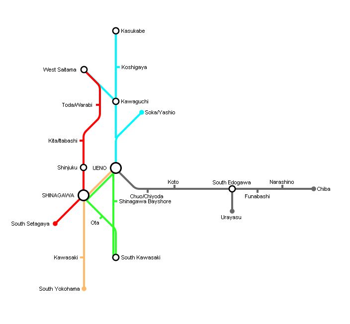
Nihon Works Corp -- Passenger Network 1930
This is from my game in my Kanto Area scenario (which you can find in the scenarios forum)
Re: Show us your network maps
Posted: 14 Jun 2012 23:35
by Aerond
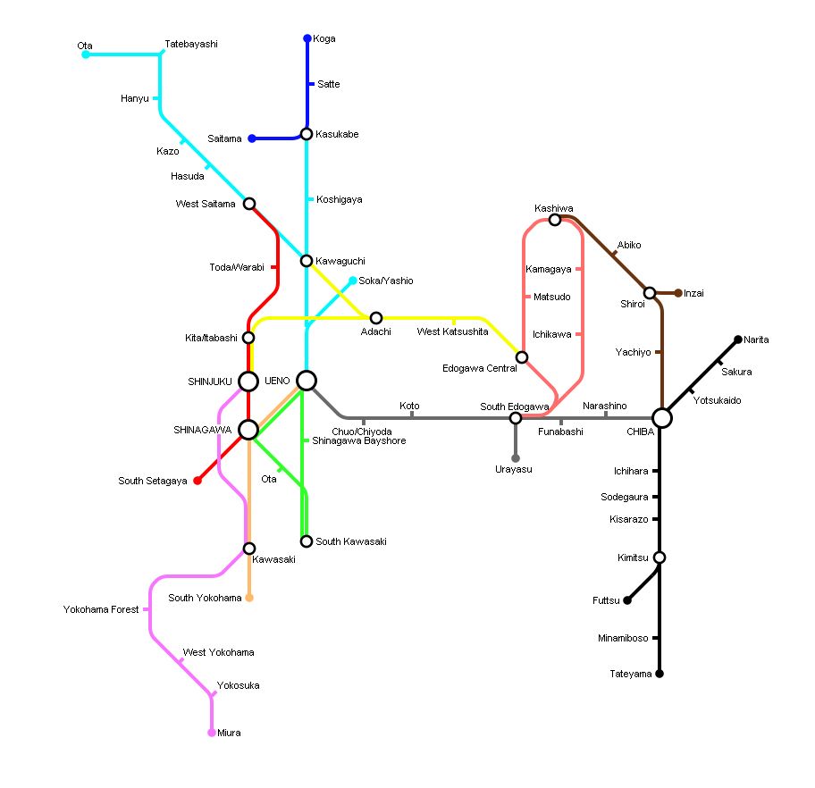
Nihon Works in 1940
Re: Show us your network maps
Posted: 15 Jun 2012 00:43
by bwong
Aerond wrote:Nihon Works in 1940
Woah woah woah! Intense things Aerond!
Do you have a screenshot thread?

I would beg to see the game you have going right now!

Re: Show us your network maps
Posted: 17 Jun 2012 00:29
by Norfolkadam
This is what I've been working on this evening. A pretty large conurbation with regional, local and high-speed lines, several major centres of population and two international airports.
I'm pretty happy with it, I think it's fairly realistic which is what I go for.
Re: Show us your network maps
Posted: 17 Jun 2012 06:04
by Goreiilar
^ I like this very much

Re: Show us your network maps
Posted: 17 Jun 2012 19:16
by bwong
Goreiilar wrote:^ I like this very much
ditto

Re: Show us your network maps
Posted: 17 Jun 2012 19:19
by GurraJG
Norfolkadam wrote:This is what I've been working on this evening. A pretty large conurbation with regional, local and high-speed lines, several major centres of population and two international airports.
I'm pretty happy with it, I think it's fairly realistic which is what I go for.
regionalrailwayshinckley.png
SWEEEEEEET! What software did you use?
Re: Show us your network maps
Posted: 17 Jun 2012 19:45
by Norfolkadam
GurraJG wrote:Norfolkadam wrote:This is what I've been working on this evening. A pretty large conurbation with regional, local and high-speed lines, several major centres of population and two international airports.
I'm pretty happy with it, I think it's fairly realistic which is what I go for.
regionalrailwayshinckley.png
SWEEEEEEET! What software did you use?
Adobe Illustrator.
Thanks for the compliments guys.
Re: Show us your network maps
Posted: 17 Jun 2012 20:29
by bwong
Norfolkadam wrote:GurraJG wrote:Norfolkadam wrote:This is what I've been working on this evening. A pretty large conurbation with regional, local and high-speed lines, several major centres of population and two international airports.
I'm pretty happy with it, I think it's fairly realistic which is what I go for.
regionalrailwayshinckley.png
SWEEEEEEET! What software did you use?
Adobe Illustrator.
Thanks for the compliments guys.
Can you upload the illustrator file? I would totally reverse engineer it. (ITS TOO AWESOME
)
Re: Show us your network maps
Posted: 18 Jun 2012 01:15
by Aerond
Nihon Works in 1950 (had to redo te map to make room at the sides for future expansion)
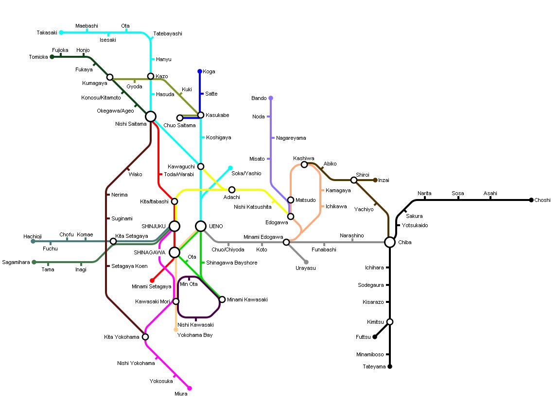
For the next 10 years I plan to start covering the cities of Western Tokyo, start expansion of the network to the NorthEast and expand the Chuo Line from Hachioji to Kofu
Re: Show us your network maps
Posted: 18 Jun 2012 19:47
by Pilot
Norfolkadam wrote:This is what I've been working on this evening. A pretty large conurbation with regional, local and high-speed lines, several major centres of population and two international airports.
I'm pretty happy with it, I think it's fairly realistic which is what I go for.
regionalrailwayshinckley.png
Do you have a Screenshot thread to post Screenies from the Game in? I'd love to see the Network. BTW Happy Birthday.
Re: Show us your network maps
Posted: 18 Jun 2012 23:28
by Level Crossing
All I'm missing is the right font...
Re: Show us your network maps
Posted: 19 Jun 2012 21:47
by Norfolkadam
bwong wrote:Can you upload the illustrator file? I would totally reverse engineer it. (ITS TOO AWESOME
)
Attached to this post for you.
A321Pilot wrote:Do you have a Screenshot thread to post Screenies from the Game in? I'd love to see the Network. BTW Happy Birthday.
I don't have one at the moment, no, but I might make one tonight or possibly this week at some point. I find it hard to make screenshot threads interesting but we'll see.
Re: Show us your network maps
Posted: 24 Jun 2012 15:53
by thphwh
I want to make some maps, but what free software should I use. Many are mentioned, but which is best. I don't really want to use MS Paint.