

Your maps are so good that there isn't really any constructive criticism that anybody could give!Norfolkadam wrote:Hope you enjoy, some constructive criticism might be good as I've never had much feedback on my maps.
Show us your network maps
Re: Show us your network maps
-
Norfolkadam

- Engineer

- Posts: 77
- Joined: 11 Jun 2010 19:16
- Location: Norfolk, UK
- Contact:
Re: Show us your network maps
*blush*Class 165 wrote:Your maps are so good that there isn't really any constructive criticism that anybody could give!Norfolkadam wrote:Hope you enjoy, some constructive criticism might be good as I've never had much feedback on my maps.
Thanks, I used to think my old maps were quite good then I look back at them and realise they're not, it's quite hard to judge your own work.
Helmland - The English and Danish island in the North Sea

Re: Show us your network maps
Indeed your map is nice but it might need a little more colour 


Re: Show us your network maps
Norfolkadam wrote:Another map from the same region. This time it's my InterCity network which is operated by 100mph EMUs on the 'vanilla' trunk lines and 187mph sets on the three express lines.
Hope you enjoy, some constructive criticism might be good as I've never had much feedback on my maps.
Oh my goodness. I love it!
Would like to see some screenshots if you have any?
Best thread ever: Network maps
Loco Scenarios: Caladras Coal - (870) Wessex - (225) Anduin Valley - (245) Sinclaire - (150) The Aural Sea - (200)
Westward Ho! - (475)
Loco Scenarios: Caladras Coal - (870) Wessex - (225) Anduin Valley - (245) Sinclaire - (150) The Aural Sea - (200)
Westward Ho! - (475)
-
Norfolkadam
- Engineer
- Posts: 77
- Joined: 11 Jun 2010 19:16
- Location: Norfolk, UK
- Contact:
Re: Show us your network maps
Thanks! Here's two for you, one of my network map and one of the main city, Oxford and the surrounding area.teccuk wrote:Norfolkadam wrote:Another map from the same region. This time it's my InterCity network which is operated by 100mph EMUs on the 'vanilla' trunk lines and 187mph sets on the three express lines.
Hope you enjoy, some constructive criticism might be good as I've never had much feedback on my maps.
Oh my goodness. I love it!
Would like to see some screenshots if you have any?
- Attachments
-
- Parker & Co., 25th May 2280.png
- (86.13 KiB) Downloaded 2 times
-
- Parker & Co., 25th May 2280#1.png
- (496.19 KiB) Downloaded 2 times
Helmland - The English and Danish island in the North Sea
Re: Show us your network maps
Wow. Thats' a great network.
Oxford suburban services look great. Close-up?
Oxford suburban services look great. Close-up?
Best thread ever: Network maps
Loco Scenarios: Caladras Coal - (870) Wessex - (225) Anduin Valley - (245) Sinclaire - (150) The Aural Sea - (200)
Westward Ho! - (475)
Loco Scenarios: Caladras Coal - (870) Wessex - (225) Anduin Valley - (245) Sinclaire - (150) The Aural Sea - (200)
Westward Ho! - (475)
-
Norfolkadam
- Engineer
- Posts: 77
- Joined: 11 Jun 2010 19:16
- Location: Norfolk, UK
- Contact:
Re: Show us your network maps
Oxford Queen St station showing the departures. It's a shame I find it harder to get more than once-an-hour services going without causing irredeemable congestion or unrealistically huge stations.teccuk wrote:Wow. Thats' a great network.
Oxford suburban services look great. Close-up?
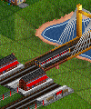
North of Oxford QS is this junction showing 2 Intercity trains coming in from Yelvertoft on the fast line and regional trains coming in from Blaydon. You'll notice that some services are missing from the departure board, that's because I got bored of this map and started a new one before I'd put trains on all the lines, also some trains going along the coast skip this station.
I think this is a pretty realistic shot of the region in question. Makes me quite happy to look at even if I'm slightly sick of the sight of it.
Helmland - The English and Danish island in the North Sea
-
iranair777
- Traffic Manager

- Posts: 163
- Joined: 13 Apr 2007 21:18
Re: Show us your network maps
^How did you get the 'regional' and 'intercity' words on the board?
-
Norfolkadam
- Engineer
- Posts: 77
- Joined: 11 Jun 2010 19:16
- Location: Norfolk, UK
- Contact:
Re: Show us your network maps
I added the trains to groups called those things then used the options menu to make the boards display train groups.iranair777 wrote:^How did you get the 'regional' and 'intercity' words on the board?
Helmland - The English and Danish island in the North Sea
-
iranair777
- Traffic Manager
- Posts: 163
- Joined: 13 Apr 2007 21:18
Re: Show us your network maps
thanksNorfolkadam wrote:I added the trains to groups called those things then used the options menu to make the boards display train groups.iranair777 wrote:^How did you get the 'regional' and 'intercity' words on the board?
Re: Show us your network maps
The Elmstead Junction shot is brilliant, picked up some signalling tips!
Best thread ever: Network maps
Loco Scenarios: Caladras Coal - (870) Wessex - (225) Anduin Valley - (245) Sinclaire - (150) The Aural Sea - (200)
Westward Ho! - (475)
Loco Scenarios: Caladras Coal - (870) Wessex - (225) Anduin Valley - (245) Sinclaire - (150) The Aural Sea - (200)
Westward Ho! - (475)
-
MinchinWeb
- Traffic Manager
- Posts: 225
- Joined: 01 Feb 2011 12:41
- Contact:
Re: Show us your network maps
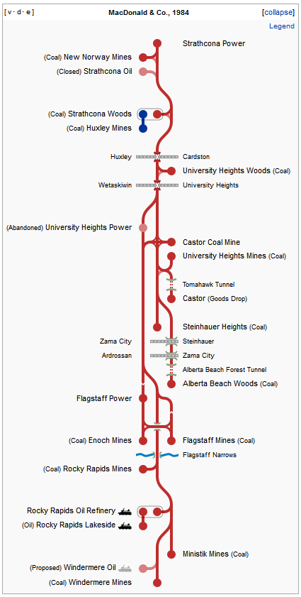
I love the idea here, so I made a map of my current game using Wikipedia. Red is the rail tracks while blue are truck routes. It's an interesting thought problem of how to make a complex 2D network into a simplified, almost 1D representation...
Enjoy!
Enjoy!
- Attachments
-
- McDonald & Co 1984.png (62.13 KiB) Viewed 948 times
Alberta Town Names - 1500+ real names from 'Acme' to 'Zama City'
MinchinWeb's Random Town Name Generator - providing 2 million plus names...
WmDOT v13 - An AI that doubles as your highway department
MinchinWeb's Random Town Name Generator - providing 2 million plus names...
WmDOT v13 - An AI that doubles as your highway department
Re: Show us your network maps
I love this network map! What application did you use to create it?Norfolkadam wrote:Another map from the same region. This time it's my InterCity network which is operated by 100mph EMUs on the 'vanilla' trunk lines and 187mph sets on the three express lines.
Hope you enjoy, some constructive criticism might be good as I've never had much feedback on my maps.
-
Norfolkadam
- Engineer
- Posts: 77
- Joined: 11 Jun 2010 19:16
- Location: Norfolk, UK
- Contact:
Re: Show us your network maps
Thanks! I used Adobe Illustrator.kotssmurf wrote:I love this network map! What application did you use to create it?Norfolkadam wrote:Another map from the same region. This time it's my InterCity network which is operated by 100mph EMUs on the 'vanilla' trunk lines and 187mph sets on the three express lines.
Hope you enjoy, some constructive criticism might be good as I've never had much feedback on my maps.
Helmland - The English and Danish island in the North Sea

Re: Show us your network maps
I've decided to change my mapping style a bit.
Drawing a separate line for each train route clutters things up far too much on a non-trivially sized network.
Map
Drawing a separate line for each train route clutters things up far too much on a non-trivially sized network.
Map
Ex TTDPatch Coder
Patch Pack, Github
Patch Pack, Github
-
iranair777
- Traffic Manager
- Posts: 163
- Joined: 13 Apr 2007 21:18
Re: Show us your network maps
that is brilliant! what did you use? Anyone have a tutorial on how to make maps like this?JGR wrote:I've decided to change my mapping style a bit.
Drawing a separate line for each train route clutters things up far too much on a non-trivially sized network.
Map
Re: Show us your network maps
Many thanks :3iranair777 wrote:that is brilliant! what did you use? Anyone have a tutorial on how to make maps like this?
I used MS Visio 2003, and I don't know of any tutorials out there.
Best to just experiment and see what style/mechanism works for you IMO.
Ex TTDPatch Coder
Patch Pack, Github
Patch Pack, Github
Re: Show us your network maps
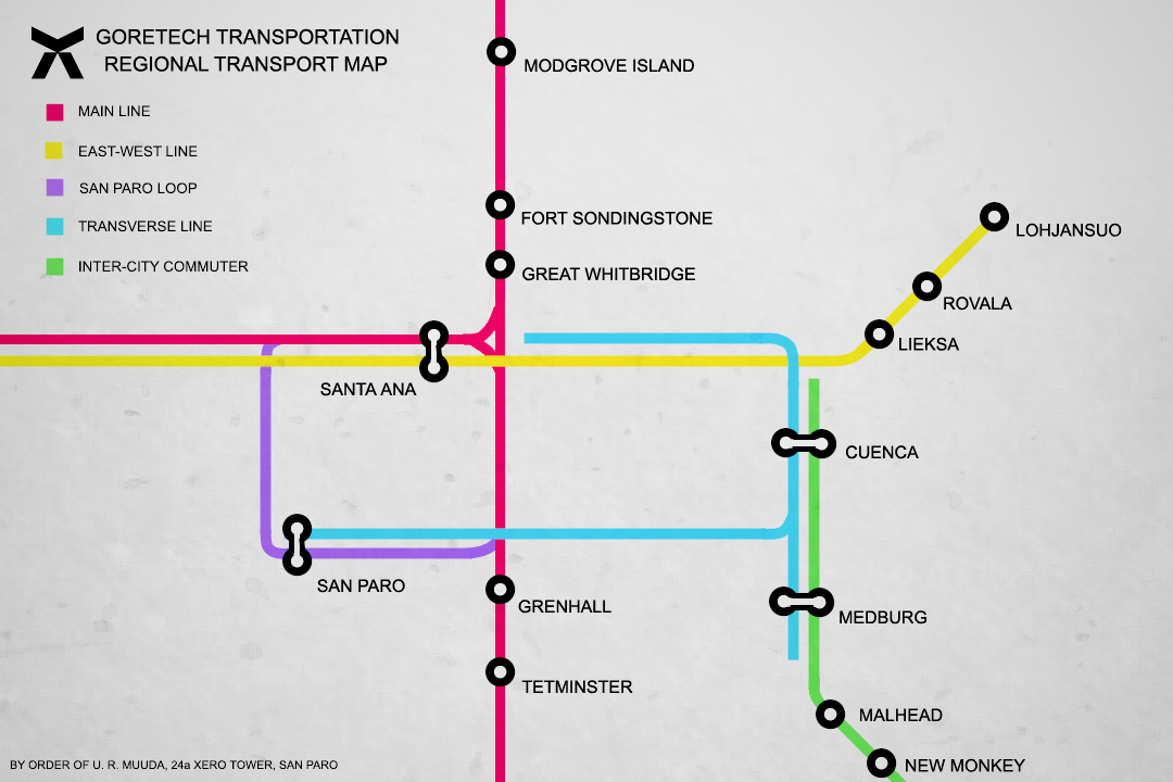
Here is my network map, made in photoshop from a save me and a mate have been working on:
- Attachments
-
- GTNetwork.png (604.41 KiB) Viewed 948 times
Re: Show us your network maps
Wahoo! New map!
I like the style, different.
I like the style, different.
Best thread ever: Network maps
Loco Scenarios: Caladras Coal - (870) Wessex - (225) Anduin Valley - (245) Sinclaire - (150) The Aural Sea - (200)
Westward Ho! - (475)
Loco Scenarios: Caladras Coal - (870) Wessex - (225) Anduin Valley - (245) Sinclaire - (150) The Aural Sea - (200)
Westward Ho! - (475)
Who is online
Users browsing this forum: No registered users and 26 guests