Page 17 of 19
Re: Show us your network maps
Posted: 23 Apr 2013 23:00
by JGR
My last OTTD game is more or less done, and I've not played in a while, so I thought I'd finish it off with a network map...
I whipped this up with Visio over the course of the evening, so there's probably scope for some improvements if I ever get round to it.
Re: Show us your network maps
Posted: 25 Apr 2013 18:40
by zooks
Metro map of Varela, made with dia (click for larger size)

Re: Show us your network maps
Posted: 27 Apr 2013 17:00
by julsteren

Red = Express train
Yellow = Fast train
Blue = Local train
Re: Show us your network maps
Posted: 29 Apr 2013 10:26
by ctiraz
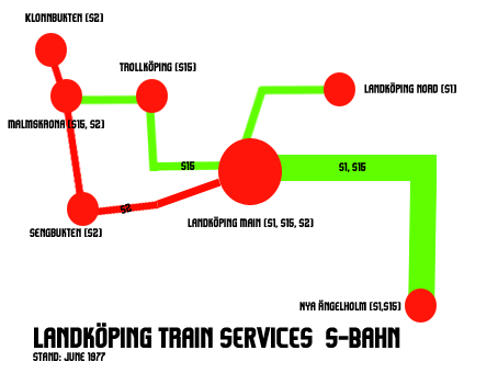
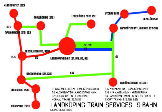
I've started new game, first part of my network as it stands in June 1977. EDIT: I've updated it, the network version as it stands in June 1980
Re: Show us your network maps
Posted: 03 May 2013 13:37
by Metrication
Re: Show us your network maps
Posted: 07 May 2013 18:29
by gogo214
Metrication wrote:
could you post a .sav? I would really like to see that network
Re: Show us your network maps
Posted: 08 May 2013 15:11
by Metrication
gogo214 wrote:Metrication wrote:
could you post a .sav? I would really like to see that network
Unfortunately I can only offer you two screenshots as I deleted the saves a while back on account of them being incompatible with the latest version of the game.
Both were taken in 1969 after 29 (I think) years of gameplay. It was a small custom scenario where I laid all the cities and industry out myself, so each town had its own unique industry.
All the teal services going into Prestbury were third rail and everything else apart from Exeter Moorside to Wellington was overhead wire.
Re: Show us your network maps
Posted: 09 May 2013 09:05
by STD
Cool building the railroad

.
Re: Show us your network maps
Posted: 09 May 2013 15:22
by zooks
Alesia, made with dia (Click for a larger version)
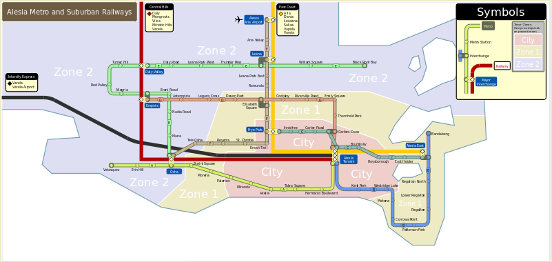 Link to thread
Re: Show us your network maps
Posted: 10 May 2013 18:04
by Yoshi
Very old map of a game by Dwight K. Schrute:
- Schienennetz.png (71.57 KiB) Viewed 3358 times
Re: Show us your network maps
Posted: 16 May 2013 21:08
by teccuk
Metrication wrote:
could you post a .sav? I would really like to see that network
Unfortunately I can only offer you two screenshots ... [/quote]
That's really lovely especially with the great screenshots. Same about the .sav
Re: Show us your network maps
Posted: 16 May 2013 23:02
by Kevo00
A map of the passenger services in my Icelandic game. Distances not entirely proportionate...
Re: Show us your network maps
Posted: 17 May 2013 06:38
by Spieler2
Hello,
this is the network map of the capital of Valland shortly called THS. The other picture shows the station "Südkreuz".
Re: Show us your network maps
Posted: 17 May 2013 11:24
by arikover
Spieler2, your map is really great! And your network seems to be quite amazing, considering the Südkreuz screenshot. (Am I wrong if I say your city is somewhat inspired by Berlin?)
Could you post some other screenshots?
Re: Show us your network maps
Posted: 17 May 2013 18:53
by michael blunck
arikover wrote:
[...] your network seems to be quite amazing, considering the Südkreuz screenshot.
But something looks wrong with that station building.
regards
Michael
Re: Show us your network maps
Posted: 21 May 2013 08:07
by Spieler2
arikover, you guess right, I like the design of Berlin network map but the city is also inspired by Leipzig. Maybe I´ll open a screenshot thread to show more pictures.
Re: Show us your network maps
Posted: 27 May 2013 10:59
by zooks
Here is another one from my last game made in dia using the solarized colour palette (click for larger):
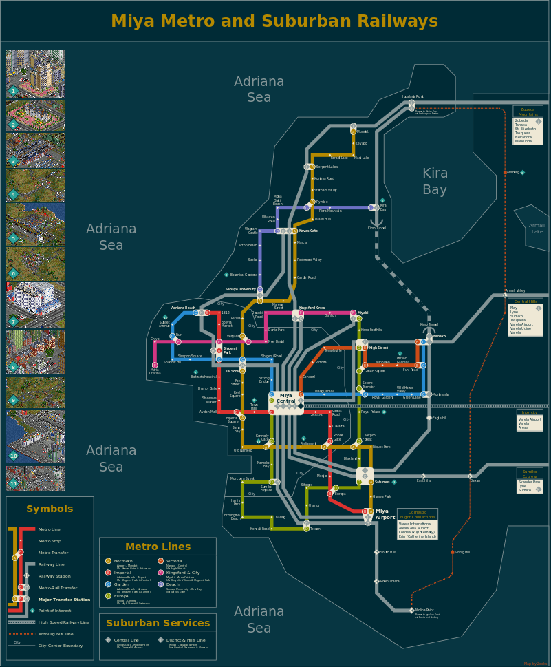
Ingame screens will be posted in
my screenshot thread
Re: Show us your network maps
Posted: 02 Aug 2013 13:22
by julsteren

Hand drawn spoorstrip.
Re: Show us your network maps
Posted: 05 Nov 2013 08:55
by Espee
Another retro map from my latest project, the
Tarborough Trunk Railway, featuring North American style railroading on a large (1024x2048) heightmap.
http://www.tt-forums.net/viewtopic.php? ... 6#p1102576
We were just founded in 1870 so we're still in the early stages of development. As of 1876 we had 5 Ten-Wheelers on our roster providing passenger service from Tarborough to Windchester and Chundnor. Here's a map of our modest system we prepared to exhibit at the American Centennial Exposition in Philadelphia that year:
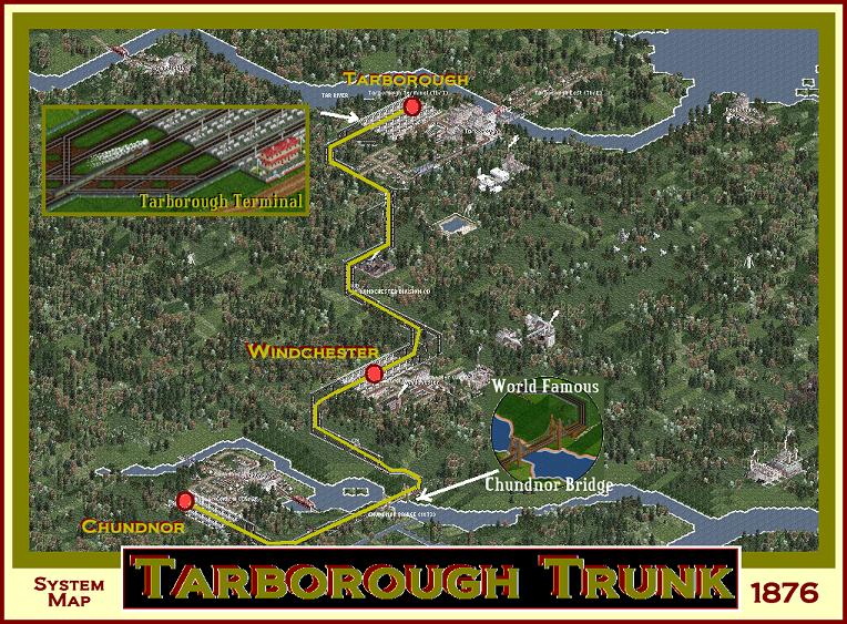
- TarboroughTrunk-SystemMap-1876k.png (852.17 KiB) Viewed 11058 times
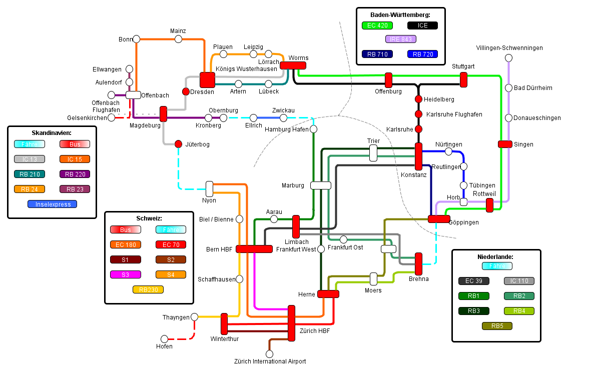
Re: Show us your network maps
Posted: 01 Nov 2014 20:37
by JGR
Here's a network map from my current game. Whilst I've not finished the game, it's probably not going to change too dramatically from this.
I've been working on this on and off for a while now so thought I ought to get round to posting it.
