How To: Generate Superb Heightmaps :)
Moderator: OpenTTD Developers

Re: How To: Generate Superb Heightmaps :)
hi i've got the google earth bit right but when i try to load the asc files onto microdem it won't let me?

Re: How To: Generate Superb Heightmaps :)
Hey nb-au, thanks for the Linux guide  I have yet to try it, don't have time now. And, welcome to the forums.

Re: How To: Generate Superb Heightmaps :)
I can't extract the files in the zip I downloaded through GE it said "No files to extract" 
-
Andrew_Jay
- Engineer

- Posts: 5
- Joined: 22 Oct 2007 23:52
Re: How To: Generate Superb Heightmaps :)
Hi,
Any suggestions for making heightmaps of your own custom terrain? I'm trying to use this as a bit of a shortcut to build my own fictional map, but I'm either not getting the results I want, or it's taking an incredible amount of work.
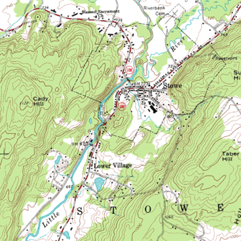
I've been using the colour codes posted by Ominus to build simple maps - black for water, and the darkest gray for level-one land. That's the easy part. Adding mountains and other features can be a pain - you either get uniform blobs, or have to labouriously draw in the bands to create a topographic map. For example, trying to create something like this:
And then shade everything the proper colour of gray.
Any suggestions for making heightmaps of your own custom terrain? I'm trying to use this as a bit of a shortcut to build my own fictional map, but I'm either not getting the results I want, or it's taking an incredible amount of work.
I've been using the colour codes posted by Ominus to build simple maps - black for water, and the darkest gray for level-one land. That's the easy part. Adding mountains and other features can be a pain - you either get uniform blobs, or have to labouriously draw in the bands to create a topographic map. For example, trying to create something like this:
And then shade everything the proper colour of gray.
-
Vestan Pance
- Engineer
- Posts: 16
- Joined: 06 Oct 2007 19:24
- Location: Edmonton, Canada
Re: How To: Generate Superb Heightmaps :)
Hi all,
As someone who lacks the tools to create heightmaps from Google Earth in the incredibly complex (to me anyway!) way described in this thread, I just wonder whether anyone would like to help me out.
I'm looking to create a realistic scenario of the Canadian province of Alberta (my home as you will see from my location). I've had a few goes at it before, originally in TTD in 2000, but it all looks so pathetic now especially now that there is the option of creating genuine heightmaps and huge 2048x2048 land sizes.
So, if anyone feels like creating this for me I would be very grateful, alternatively if someone could give me any tips on creating it for myself using other resources I would be interested to hear that too. Ideal size for it I think would be 1024x2048.
Thanks in advance to anyone with helpful advice.
For a moment, I was in someone else's plush, squeaking armchair.

Re: How To: Generate Superb Heightmaps :)
I generated simple heightmap of Poland and some neighbouring countries (using GDAL method mentioned above), you can use it of course, but it require some reworking because as for now for example: Baltic Sea is not at sea level, and Wisła (Vistula) river too.
- Attachments
-
- mapka.png
- (1.82 MiB) Downloaded 596 times
-
meowsqueak
- Engineer
- Posts: 48
- Joined: 05 Jul 2006 22:25
Re: How To: Generate Superb Heightmaps :)
I can get as far as the PNG files but it seems the height data from that source is 'truncated' and produces vast expanses of 100% white pixels? The mountains around here are all flat-topped - maybe at 200 metres or so? Makes the entire country look like a tabletop.nb-au wrote:At this stage you have a greyscale PNG, which works great in OpenTTD.

Re: How To: Generate Superb Heightmaps :)
Hy! I have a huge problem! I`ve downloaded MicroDem from here http://www.usna.edu/Users/oceano/pguth/ ... emdown.htm , the complete MICRODEM install (40 MB). I`m from Romania and for my region was 4 zip files! I`ve downloaded them and extract the ASC files (each file has over 100 MB). Now after i`ve installed microdem, when i want to open the ASC files I get lots of erors! i`ve updated microdem.exe to 01-Nov-2007 15:34 5.8M version and i still get those erors!
I use Google Earth 4.2.0198.2451 (beta) from earth.google.com
Srtm3.kmz found on internet
I use Google Earth 4.2.0198.2451 (beta) from earth.google.com
Srtm3.kmz found on internet
The rest is confetti!

Re: How To: Generate Superb Heightmaps :)
Mentioning the "erors" [sic] might make it easier for someone who knows to tell you what's wrong.
To get a good answer, ask a Smart Question. Similarly, if you want a bug fixed, write a Useful Bug Report. No TTDPatch crashlog? Then follow directions.
Projects: NFORenum (download) | PlaneSet (Website) | grfcodec (download) | grfdebug.log parser
Projects: NFORenum (download) | PlaneSet (Website) | grfcodec (download) | grfdebug.log parser
Re: How To: Generate Superb Heightmaps :)
Ok! the errors are:
"Access violation at address 00870102 in module 'microdem.exe'. Read of address 00000001."
"I/O error 104"
"Access violation at address 00870102 in module 'microdem.exe'. Read of address 00000001."
"I/O error 104"
The rest is confetti!
Re: How To: Generate Superb Heightmaps :)
Hi, I have same problem like the guy above me  Is there any solution?
I tried to open some example from Microdem SW and it worked just fine. But opening ASC files downloaded from googleEarth does not work. I tried even the maps mentioned in the very begging of this tutorial (Haiti & the Domincan Republic), w/out success ... I would like to make heightmap of Czech Republic (Top left: 51°5'46.876"N, 11°49'57.912"E, bottom right: 48°27'28.721"N, 18°53'4.3"E), if there still that project running (dont remember they guy who is making it), I would very appreciate grayscale map for this location. Thx.
PS: Any other way of help is welcome
Re: How To: Generate Superb Heightmaps :)
Its much higher then that (ive noticed it too) Id have a guess its about 700-800m +meowsqueak wrote:I can get as far as the PNG files but it seems the height data from that source is 'truncated' and produces vast expanses of 100% white pixels? The mountains around here are all flat-topped - maybe at 200 metres or so? Makes the entire country look like a tabletop.nb-au wrote:At this stage you have a greyscale PNG, which works great in OpenTTD.
The problem probably is one of the following:
1) SEMI-FIXABLE: OpenTTD reads pixels with over a certain level of white as max height, this should be fixable by finding this level and making the readjusting the colors of the image accordingly so that it is the max height and all other levels fit in between (relatively easy in GIMP or PS). The scale height will seem lower though.
2) NON-FIXABLE (without source tinkering): OpenTTD has a limited number of levels of height. Your image has the equivalent of more then those levels, so the tops get cut off.
3) NON-FIXABLE (without source tinkering): A problem related to how OpenTTD reads bitmaps. Maybe there is a bug?
It might be possible to use the gradient tool to do something, it'll still take a lot of work. But it would reduce stepping/terracing.Andrew_Jay wrote:Hi,
Any suggestions for making heightmaps of your own custom terrain? I'm trying to use this as a bit of a shortcut to build my own fictional map, but I'm either not getting the results I want, or it's taking an incredible amount of work.
I've been using the colour codes posted by Ominus to build simple maps - black for water, and the darkest gray for level-one land. That's the easy part. Adding mountains and other features can be a pain - you either get uniform blobs, or have to labouriously draw in the bands to create a topographic map. For example, trying to create something like this:
And then shade everything the proper colour of gray.
Re: How To: Generate Superb Heightmaps :)
I noticed above someone requested a height map of Alberta
if someone could ..please do
Alberta 2000x1000 ish
about that size ..lotsa detail
cheers
Madwack
if someone could ..please do
Alberta 2000x1000 ish
about that size ..lotsa detail
cheers
Madwack
-
meowsqueak
- Engineer
- Posts: 48
- Joined: 05 Jul 2006 22:25
Re: How To: Generate Superb Heightmaps :)
Actually, I meant that the problem is with the generation of the PNG images with the GDAL tool - before OpenTTD reads anything. The raw height data seems to be truncated at some altitude. This makes the very mountainous terrain of New Zealand come out like a big flat (white) sheet. OpenTTD reads this but it's all high and flat of course.nb-au wrote:Its much higher then that (ive noticed it too) Id have a guess its about 700-800m +meowsqueak wrote:I can get as far as the PNG files but it seems the height data from that source is 'truncated' and produces vast expanses of 100% white pixels? The mountains around here are all flat-topped - maybe at 200 metres or so? Makes the entire country look like a tabletop.nb-au wrote:At this stage you have a greyscale PNG, which works great in OpenTTD.
The problem probably is one of the following:
1) SEMI-FIXABLE: OpenTTD reads pixels...
Re: How To: Generate Superb Heightmaps :)
Oh, in that case i guess you could try messing around with command line instructions. If you figure anything out, post it. Itd be nice to actually see the top of Australia's Great Dividing Range. Id actually just figured it was GDAL in the last day or two myself as my heghtmaps in Simcity 4 were doing the same things.meowsqueak wrote:Actually, I meant that the problem is with the generation of the PNG images with the GDAL tool - before OpenTTD reads anything. The raw height data seems to be truncated at some altitude. This makes the very mountainous terrain of New Zealand come out like a big flat (white) sheet. OpenTTD reads this but it's all high and flat of course.
Re: How To: Generate Superb Heightmaps :)
That Linux heightmap guide was very useful! Thanks for the post.
I made a heightmap of the Greatlakes area by combining four/eight 512x512 pngs:
These are the heightmaps from GDAL. It is a bit "whitewashed" and OpenTTD doesn't read the water level. If you want to mess with the colors yourself, you can use this.


These are the colorcorrected heightmaps that I edited with GIMP. I made the "sealevel" even with the lake surface, and toned down the brightness to remove the gigantic steps of white. You can bring this into the OpenTTD editor with no problems.


This is a 512x1024 scenario file with placed cities from an atlas. I did not add any industries, so you can edit that to your liking.


Re: How To: Generate Superb Heightmaps :)
grim4593, thank you so much! 
When I get around to it, will tweak the city populations, and add rivers if possible. Possibly even the Erie Canal and its feeders. Will break out the atlas and add appropriate industries also. Those iron boats have to come to Buffalo, and grain also.
When I get around to it, will tweak the city populations, and add rivers if possible. Possibly even the Erie Canal and its feeders. Will break out the atlas and add appropriate industries also. Those iron boats have to come to Buffalo, and grain also.
Who is John Galt?
Re: How To: Generate Superb Heightmaps :)
That would be pretty cool. Can we make "rivers" now? That was the reason I didn't add the major rivers, you can't have water tiles off sealevel, and canals just looked goofy IMO.


Re: How To: Generate Superb Heightmaps :)
Here is the heightmap of Alberta, Canada requested in previous posts...
Based on SRTM, 1:2, needs some work in the north-east part...
Based on SRTM, 1:2, needs some work in the north-east part...
- Attachments
-
- ALBERTACANADA.PNG (238.33 KiB) Viewed 1885 times
Playing TT & TTD since 1995 - Will satisfy the Megalomaniac in everyone!
Click here to see all my maps!
Highlights:
CarstsEuropeScenario based on SRTM-Data (Redo planned)
CarstsWorldScenario based on satellite heightmap
CarstsGermanyScenario coming soon...
CarstsBerlinBburgScenario planned...
Click here to see all my maps!
Highlights:
CarstsEuropeScenario based on SRTM-Data (Redo planned)
CarstsWorldScenario based on satellite heightmap
CarstsGermanyScenario coming soon...
CarstsBerlinBburgScenario planned...
-
kevin.carbonaro
- Engineer
- Posts: 5
- Joined: 10 Feb 2008 15:04
- Skype: kevin.carbonaro
- Location: Malta
- Contact:
The Maltese Islands HeightMap (.PNG)
Thanks to nb-au 's instructions I managed to get the heightmap for Malta.
I have attached the .PNG file which is 2048 x 2048 ready to be imported in TTD.
Hopefully I'll find some time to add some of the major cities and towns on the islands. If and when this is done, I will make the scenario available for download.
Kevin C.
I have attached the .PNG file which is 2048 x 2048 ready to be imported in TTD.
Hopefully I'll find some time to add some of the major cities and towns on the islands. If and when this is done, I will make the scenario available for download.
Kevin C.
- Attachments
-
- TheMalteseIslands.png
- (376.5 KiB) Downloaded 1292 times
Who is online
Users browsing this forum: Amazon [Bot] and 20 guests